IMAGES TAKEN NEAR TO
Devonshire Gardens, WALLSEND, NE28 8EA
Introduction
This page details the photographs taken nearby to Devonshire Gardens, NE28 8EA by members of the Geograph project.
The Geograph project started in 2005 with the aim of publishing, organising and preserving representative images for every square kilometre of Great Britain, Ireland and the Isle of Man.

There are currently over 7.5m images from over14,400 individuals and you can help contribute to the project by visiting https://www.geograph.org.uk
Image Map
Images are licensed for reuse under creativecommons.org/licenses/by-sa/2.0
Notes
- Clicking on the map will re-center to the selected point.
- The higher the marker number, the further away the image location is from the centre of the postcode.
Image Listing (15 Images Found)
Images are licensed for reuse under creativecommons.org/licenses/by-sa/2.0
Image
Details
Distance
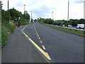
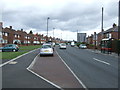
3
Wiltshire Gardens 2007 in the distance
Image: © Mac McCarron
Taken: 21 Oct 2007
0.09 miles
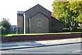
5
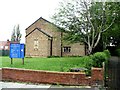
The Church of St John The Evangelist, Station Road, Wallsend
Image: © Bill Henderson
Taken: 10 Jun 2012
0.10 miles
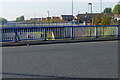
6
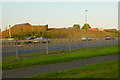
Wiltshire Gardens "Maisonettes" 2007
The maisonettes were demolished and the land sold for private housing.
Image: © Mac McCarron
Taken: 20 Oct 2007
0.10 miles
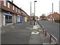
9
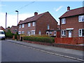
Dorset Avenue, Wallsend
Local authority housing of the 1950s.
Image: © Mac McCarron
Taken: 20 Jun 2008
0.15 miles
