IMAGES TAKEN NEAR TO
Mayfield Gardens, WALLSEND, NE28 8AT
Introduction
This page details the photographs taken nearby to Mayfield Gardens, NE28 8AT by members of the Geograph project.
The Geograph project started in 2005 with the aim of publishing, organising and preserving representative images for every square kilometre of Great Britain, Ireland and the Isle of Man.

There are currently over 7.5m images from over14,400 individuals and you can help contribute to the project by visiting https://www.geograph.org.uk
Image Map
Images are licensed for reuse under creativecommons.org/licenses/by-sa/2.0
Notes
- Clicking on the map will re-center to the selected point.
- The higher the marker number, the further away the image location is from the centre of the postcode.
Image Listing (11 Images Found)
Images are licensed for reuse under creativecommons.org/licenses/by-sa/2.0
Image
Details
Distance
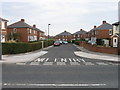
1
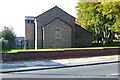
Wiltshire Gardens "Maisonettes" 2007
The maisonettes were demolished and the land sold for private housing.
Image: © Mac McCarron
Taken: 20 Oct 2007
0.03 miles
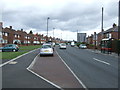
2
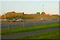
Wiltshire Gardens 2007 in the distance
Image: © Mac McCarron
Taken: 21 Oct 2007
0.05 miles
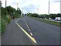
6
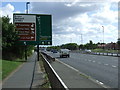
Cycleway alongside the Coast Road
For almost its entire length, the busy Coast Road A1058 is followed by a cycle- and foot-path along the north side.
Image: © Oliver Dixon
Taken: 4 Dec 2013
0.19 miles
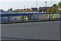
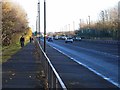
9
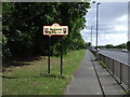
Cycle path beside the A1058
Entering Wallsend.
Image: © JThomas
Taken: 3 Aug 2013
0.20 miles