IMAGES TAKEN NEAR TO
Archer Street, WALLSEND, NE28 7AA
Introduction
This page details the photographs taken nearby to Archer Street, NE28 7AA by members of the Geograph project.
The Geograph project started in 2005 with the aim of publishing, organising and preserving representative images for every square kilometre of Great Britain, Ireland and the Isle of Man.

There are currently over 7.5m images from over14,400 individuals and you can help contribute to the project by visiting https://www.geograph.org.uk
Image Map
Images are licensed for reuse under creativecommons.org/licenses/by-sa/2.0
Notes
- Clicking on the map will re-center to the selected point.
- The higher the marker number, the further away the image location is from the centre of the postcode.
Image Listing (52 Images Found)
Images are licensed for reuse under creativecommons.org/licenses/by-sa/2.0
Image
Details
Distance
3
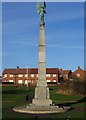
Wallsend War Memorial
Hidden by scrubby parkland, but with a wonderful view across the Tyne Valley, this memorial deserves to be better looked after. Surely a few shrubs and flowers would help...or are the authorities so cynical as to be believe it would be a wasted effort?
Image: © Alan Fearon
Taken: 16 Dec 2005
0.08 miles
4
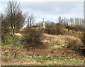
War Memorial
The memorial is near the slopes of Wallsend Dene - taken from the opposite square
Image: © Christine Westerback
Taken: 16 Mar 2012
0.08 miles
5
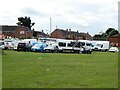
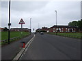
Major construction site off Archer Street
Understood to be construction of facilities for a youth club.
Image: © Oliver Dixon
Taken: 6 Jul 2023
0.09 miles
6
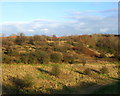
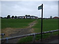
Wallsend 'Park'
This open land in front of Wallsend War memorial http://www.geograph.org.uk/photo/91994 runs steeply down to Willington Gut, part of Wallsend Burn. Perhaps the 'Friends of Wallsend Park' could include this area in their consideration as it would make a beautiful park if some money could be made available.
Image: © Alan Fearon
Taken: 16 Dec 2005
0.13 miles
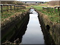
7
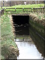
Wallsend Burn
The waters of the burn as it goes under the main road into Willington Gut
Image: © Christine Westerback
Taken: 16 Mar 2012
0.17 miles
8
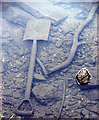
Abandoned Spade
In the waters of Wallsend Burn
Image: © Christine Westerback
Taken: 16 Mar 2012
0.17 miles
10
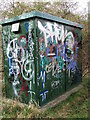
Decorated Container
Not sure what this is used for other than a canvass for graffiti artists
Image: © Christine Westerback
Taken: 16 Mar 2012
0.17 miles