IMAGES TAKEN NEAR TO
The Avenue, WALLSEND, NE28 6BT
Introduction
This page details the photographs taken nearby to The Avenue, NE28 6BT by members of the Geograph project.
The Geograph project started in 2005 with the aim of publishing, organising and preserving representative images for every square kilometre of Great Britain, Ireland and the Isle of Man.

There are currently over 7.5m images from over14,400 individuals and you can help contribute to the project by visiting https://www.geograph.org.uk
Image Map
Images are licensed for reuse under creativecommons.org/licenses/by-sa/2.0
Notes
- Clicking on the map will re-center to the selected point.
- The higher the marker number, the further away the image location is from the centre of the postcode.
Image Listing (53 Images Found)
Images are licensed for reuse under creativecommons.org/licenses/by-sa/2.0
Image
Details
Distance
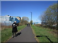
1
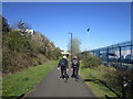
Neptune Road
Leading to Wallsend and the Segedunum Roman ruins.
Image: © Stephen Sweeney
Taken: 7 Jan 2009
0.07 miles
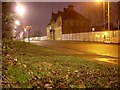
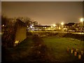
3
Tumulus and Philiphaugh from Walkerdene House
Aerial view taken from 14th Floor of Walkerdene House 1974. Pete Watsons shop visible at top of photograph. Demolition of the end of Philiphaugh just recent and road closed.
Image: © Wayne Phillips
Taken: 1 Oct 1974
0.10 miles
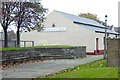
9
Replica of Hadrian's Wall
Exact copy of how the wall would have looked, located right beside its original route.
Image: © Stephen Sweeney
Taken: 7 Jan 2009
0.16 miles