IMAGES TAKEN NEAR TO
The Silverlink North, NEWCASTLE UPON TYNE, NE27 9SG
Introduction
This page details the photographs taken nearby to The Silverlink North, NE27 9SG by members of the Geograph project.
The Geograph project started in 2005 with the aim of publishing, organising and preserving representative images for every square kilometre of Great Britain, Ireland and the Isle of Man.

There are currently over 7.5m images from over14,400 individuals and you can help contribute to the project by visiting https://www.geograph.org.uk
Image Map (Loading...)


Getting Data...Please wait
Leaflet Map data © OpenStreetMap
Images are licensed for reuse under creativecommons.org/licenses/by-sa/2.0
Notes
- Clicking on the map will re-center to the selected point.
- The higher the marker number, the further away the image location is from the centre of the postcode.
Image Listing (91 Images Found)
Images are licensed for reuse under creativecommons.org/licenses/by-sa/2.0
Image
Details
Distance
1

Cobalt Business Park - North Tyneside Council Offices
Previously council departments were spread all over the borough and now many have been collected under one roof.
Image: © Mac McCarron
Taken: 30 Jan 2009
0.00 miles

3

Council office, Cobalt Business Park
This modern office building, forming part of the Cobalt Business Park, is occupied by North Tyneside Council, the unitary authority responsible for providing services to the surrounding area.
Image: © Graham Robson
Taken: 1 May 2017
0.04 miles
4
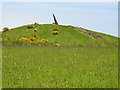
Silverlink Park Sundial
In 1996 work started on reclaiming the West Allotment Tip and the remains of the spoil heap from the former Backworth Colliery (Algernon Pit). The large mound at the centre of the park forms the highest ground in North Tyneside and provides panoramic views of the area. It is also the site of the Silverlink Sundial.
Image: © Ken Brown
Taken: 17 May 2005
0.05 miles
5
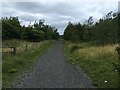
Path to the Sundial, Silverlink Biodiversity Park
Image: © Anthony Foster
Taken: 1 Aug 2020
0.08 miles
6

Path, Silverlink Biodiversity Park, Shiremoor
The Silverlink Biodiversity Park was created in 1996, on the site of a former rubbish tip, as part of a new business park development scheme. It covers an area of approximately 18 hectares and contains a variety of woodland, scrub and hedgerow, grassland and tall herb, wetland and exposed rock habitats. A giant sundial sits on top of a central hill which can be reached via a spider's web of footpaths. The park was declared a Local Nature Reserve in 2005. This path lies at the base of the central hill and leads to the steps which climb to the top of the hill. For a selection of detailed free to download walking routes in the area visit www.northtynesidewalks.co.uk
Image: © Geoff Holland
Taken: 12 Jul 2020
0.09 miles
7
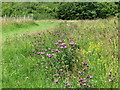
Wildflowers, Silverlink Biodiversity Park, Shiremoor
The two predominant species in this stretch of path side meadow are Common Knapweed and Lady's Bedstraw. Common Knapweed, also known as Hardheads and Black Knapweed, is a firm favourite of pollinating insects, being a source of good quality nectar. As well as supporting bees, butterflies and beetles its seeds provide food for many birds. Lady's Bedstraw, when dried, has the scent of new-cut hay, and its name is probably derived from the tradition of stuffing straw mattresses with it, particularly those of women about to give birth. The Silverlink Biodiversity Park was created in 1996, on the site of a former rubbish tip, as part of a new business park development scheme. It covers an area of approximately 18 hectares and contains a variety of woodland, scrub and hedgerow, grassland and tall herb, wetland and exposed rock habitats. A giant sundial sits on top of a central hill which can be reached via a spider's web of footpaths. The park was declared a Local Nature Reserve in 2005. For a selection of detailed free to download walking routes in the area visit www.northtynesidewalks.co.uk
Image: © Geoff Holland
Taken: 12 Jul 2020
0.09 miles
8
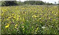
Wild Flowers Silverlink Biodiversity Park, Shiremoor
This biodiversity park lies in the middle of a business park and was created on the site of the old West Allotment tip (see https://www.geograph.org.uk/photo/11988). During the height of summer it is awash with a wide variety of wild flowers. For a selection of detailed free to download walking routes in the area visit www.northtynesidewalks.co.uk
Image: © Geoff Holland
Taken: 14 Jul 2019
0.10 miles
9
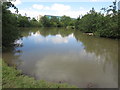
Pond, Silverlink Biodiversity Park, Shiremoor
This is one of a number of small ponds located within the Silverlink Biodiversity Park. The Park was created in 1996, on the site of a former rubbish tip, as part of a new business park development scheme. It covers an area of approximately 18 hectares and contains a variety of woodland, scrub and hedgerow, grassland and tall herb, wetland and exposed rock habitats. A giant sundial sits on top of a central hill which can be reached via a spider's web of footpaths. The park was declared a Local Nature Reserve in 2005. For selection of detailed free to download walking routes in the area visit www.northtynesidewalks.co.uk
Image: © Geoff Holland
Taken: 19 Jul 2020
0.10 miles
10
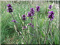
Betony, Silverlink Biodiversity Park, Shiremoor
Betony prefers dry, light soils often on sunny banks and hedgerows, on heathland and other grassy places including, occasionally, the undisturbed margins of arable fields. It can also be an indicator of ancient woodland. The Silverlink Biodiversity Park was created in 1996, on the site of a former rubbish tip, as part of a new business park development scheme. It covers an area of approximately 18 hectares and contains a variety of woodland, scrub and hedgerow, grassland and tall herb, wetland and exposed rock habitats. A giant sundial sits on top of a central hill which can be reached via a spider's web of footpaths. The park was declared a Local Nature Reserve in 2005. For a selection of detailed free to download walking routes in the area visit www.northtynesidewalks.co.uk
Image: © Geoff Holland
Taken: 1 Aug 2020
0.10 miles