IMAGES TAKEN NEAR TO
Carlisle Close, NEWCASTLE UPON TYNE, NE27 0UT
Introduction
This page details the photographs taken nearby to Carlisle Close, NE27 0UT by members of the Geograph project.
The Geograph project started in 2005 with the aim of publishing, organising and preserving representative images for every square kilometre of Great Britain, Ireland and the Isle of Man.

There are currently over 7.5m images from over14,400 individuals and you can help contribute to the project by visiting https://www.geograph.org.uk
Image Map (Loading...)


Getting Data...Please wait
Leaflet Map data © OpenStreetMap
Images are licensed for reuse under creativecommons.org/licenses/by-sa/2.0
Notes
- Clicking on the map will re-center to the selected point.
- The higher the marker number, the further away the image location is from the centre of the postcode.
Image Listing (10 Images Found)
Images are licensed for reuse under creativecommons.org/licenses/by-sa/2.0
Image
Details
Distance
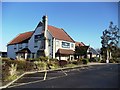
1
Pylon near Scaffold Hill Farm
On the south side of Holystone village.
Image: © Robert Graham
Taken: 5 Jun 2023
0.13 miles
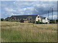
2
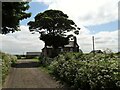
Scaffold Hill Farm
This old farm at Benton is north of the Rising Sun Country Park. It is shown on an estate map of 1800, and the present buildings are shown on the 1865 First Series Ordnance Survey map.
Image: © Robert Graham
Taken: 5 Jun 2023
0.16 miles
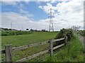
3
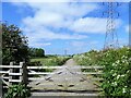
Gate across the footpath
This is the path from Scaffold Hill Farm leading to Whitley Road, with the power line marching along beside it.
Image: © Robert Graham
Taken: 5 Jun 2023
0.17 miles
4

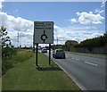
No 51 bus in Holystone
Bus coming south down Whitley Road. This is the Arriva N0 51 service, running between Whitley Bay and Newcastle via Holystone village.
Image: © Robert Graham
Taken: 5 Jun 2023
0.18 miles
7
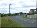
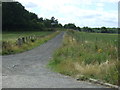
A bend in Holystone Way (A191)
Towards Newcastle.
Image: © JThomas
Taken: 3 Aug 2013
0.21 miles