IMAGES TAKEN NEAR TO
Greenrigg, WHITLEY BAY, NE26 4HN
Introduction
This page details the photographs taken nearby to Greenrigg, NE26 4HN by members of the Geograph project.
The Geograph project started in 2005 with the aim of publishing, organising and preserving representative images for every square kilometre of Great Britain, Ireland and the Isle of Man.

There are currently over 7.5m images from over14,400 individuals and you can help contribute to the project by visiting https://www.geograph.org.uk
Image Map
Images are licensed for reuse under creativecommons.org/licenses/by-sa/2.0
Notes
- Clicking on the map will re-center to the selected point.
- The higher the marker number, the further away the image location is from the centre of the postcode.
Image Listing (26 Images Found)
Images are licensed for reuse under creativecommons.org/licenses/by-sa/2.0
Image
Details
Distance
3
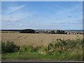
Arable land at Lookout Farm
A field of wheat growing beside the converted farm buildings at Lookout Farm.
Image: © Graham Robson
Taken: 29 Aug 2016
0.14 miles
4
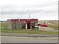
Public toilets at the north end of Seaton Sluice
Council operated public toilets situated in a car park on the coast at the northern end of Seaton Sluice.
Image: © Graham Robson
Taken: 20 Feb 2016
0.18 miles
5
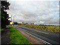
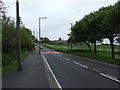
The Avenue, Seaton Sluice
This road runs west from the village, inland to Seaton Delavel. The farm just up the road is Lookout Farm.
Image: © Robert Graham
Taken: 3 Oct 2012
0.19 miles
6
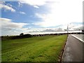
Hartley Links
These run alongside Links Road in Seaton Sluice. View looking south.
Image: © Robert Graham
Taken: 3 Oct 2012
0.19 miles
7
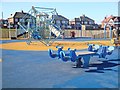
Children's playground on Seaton Sluice Beach
Colourful playground apparatus on a safe base.
Image: © Joan Sykes
Taken: 1 Mar 2010
0.20 miles
8
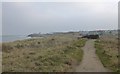
Coast Path heading for Seaton Sluice
Between Links Road and the beach.
Image: © Russel Wills
Taken: 26 Jan 2017
0.20 miles
9
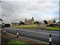
Lookout Farm, Seaton Sluice
This big old farm is on The Avenue, which leads to Seaton Delavel. It gets its name obviously because it is on a slight rise which gives a good viewpoint in a very flat landscape.
Image: © Robert Graham
Taken: 3 Oct 2012
0.21 miles