IMAGES TAKEN NEAR TO
Millway, WHITLEY BAY, NE26 4DJ
Introduction
This page details the photographs taken nearby to Millway, NE26 4DJ by members of the Geograph project.
The Geograph project started in 2005 with the aim of publishing, organising and preserving representative images for every square kilometre of Great Britain, Ireland and the Isle of Man.

There are currently over 7.5m images from over14,400 individuals and you can help contribute to the project by visiting https://www.geograph.org.uk
Image Map
Images are licensed for reuse under creativecommons.org/licenses/by-sa/2.0
Notes
- Clicking on the map will re-center to the selected point.
- The higher the marker number, the further away the image location is from the centre of the postcode.
Image Listing (95 Images Found)
Images are licensed for reuse under creativecommons.org/licenses/by-sa/2.0
Image
Details
Distance
1

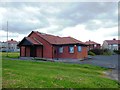
The Co-operative Food, Seaton Sluice
A small supermarket in the village of Seaton Sluice.
Image: © Graham Robson
Taken: 20 Feb 2016
0.04 miles
2
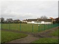
Seaton Sluice Bowling Club
Looking across the bowling green towards the pavilion of the bowls club in Seaton Sluice.
Image: © Graham Robson
Taken: 20 Feb 2016
0.07 miles
4

Allotments, Beresford Road, Seaton Sluice
These allotments cover a fairly large area lying between Beresford Road and Collywell Bay Road. Whilst the history of allotments goes back many centuries, it was not until the Small Holdings and Allotments Act 1908 came into force that local authorities were legally obliged to provide "sufficient allotments according to demand". This duty was further extended with the passing of the Land Settlement Facilities Act 1919 with the rights of allotment holders being strengthened by the Allotments Act 1922. However, the most important change was introduced when the Allotments Act 1925 established statutory allotments which local authorities could not sell off or covert to other uses without Ministerial consent. For a selection of detailed free to download walking routes in the area visit www.northtynesidewalks.co.uk
Image: © Geoff Holland
Taken: 6 Oct 2020
0.12 miles
6
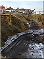
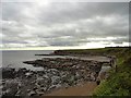
Coastal defences, Collywell Bay
See another photo for a brief discussion of the geology: Image
There is a good disscussion about erosion of this coastline, including the measures taken to protect the cliff face below the houses on Collywell Bay Road, in Chapter 8, 'Changing Coastal Environments' in Changing Environments by Susan Bermingham (2000).
The most recent sea defences comprising large concrete slabs attached to the cliff face at the northern end of the bay were completed in 1981. The older, cliff-base, defenses in the foreground have brought about an accelerated rate of sand removal from the natural protection afforded by the beach of Collywell Sands which used to extend below the cliffs. Undercutting of the defenses is now taking place as a result of increased wave energy. The movement west of the mean high water mark is clearly demonstrated by comparison of old maps.
Image: © Andrew Curtis
Taken: 10 Dec 2017
0.13 miles
7
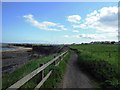
Public Footpath Skirting Collywell Bay
Image: © Bill Henderson
Taken: 1 Jun 2013
0.13 miles
9
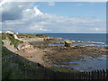
Collywell Bay, Seaton Sluice
A rocky bay on the east side of the village. The cliffs continue from here south to Whitley Bay, gradually getting lower.
Image: © Robert Graham
Taken: 3 Oct 2012
0.15 miles
10
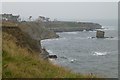
View across Collywell Bay at high tide
Seaton Sluice high on the left.
Image: © Russel Wills
Taken: 26 Jan 2017
0.16 miles