IMAGES TAKEN NEAR TO
Hastings Avenue, WHITLEY BAY, NE26 4AF
Introduction
This page details the photographs taken nearby to Hastings Avenue, NE26 4AF by members of the Geograph project.
The Geograph project started in 2005 with the aim of publishing, organising and preserving representative images for every square kilometre of Great Britain, Ireland and the Isle of Man.

There are currently over 7.5m images from over14,400 individuals and you can help contribute to the project by visiting https://www.geograph.org.uk
Image Map
Images are licensed for reuse under creativecommons.org/licenses/by-sa/2.0
Notes
- Clicking on the map will re-center to the selected point.
- The higher the marker number, the further away the image location is from the centre of the postcode.
Image Listing (76 Images Found)
Images are licensed for reuse under creativecommons.org/licenses/by-sa/2.0
Image
Details
Distance
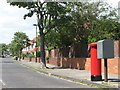
2
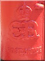
Edward VIII postbox, Hastings Avenue - royal cipher
See Image
Image: © Mike Quinn
Taken: 9 Jun 2008
0.08 miles
3
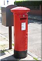
Edward VIII postbox, Hastings Avenue
The location of this postbox is shown in Image
Image: © Mike Quinn
Taken: 9 Jun 2008
0.09 miles
4
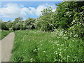
Path through the Brierdene, Whitley Bay
This is the main path through the Brierdene and lies on the northern side of the Brierdene Burn. The Brierdene is an area managed by Friends of Brierdene www.friendsof brierdene.org.uk with assistance from North Tyneside Council. This poem was inspired by the dene and first appeared in the book, 'Green Spaces Parks, Poetry and Hidden Nature in North Tyneside' published by North Tyneside Council and Northern Voices Community Projects.
BRIERDENE
Woods were once swung here,
sand wedges, chips and pitches,
fairways and manicured greens,
golfers aiming putters with precision,
brightly patterned sweaters,
and a wee flagged hole
at the end of it all.
They took the rough with the smooth.
Now, sandwiched between houses,
surrounded by a rich variety of trees,
the burn slips quietly past and,
a pebble's throw away,
it spills out across the sands.
I have often wondered
just how many culverts
has it flowed through on
its journey from its source to the sea.
I have wondered how many farms
have seen its rise and fall,
its cargo of water borne debris,
logs, sticks and branches,
rich pickings from upstream.
From this sheltered dene,
far removed from the seaside hurly-burly,
I watch the seasons change,
the migrants come and go,
the trees cast off their leaves.
And when, in time, it is all done,
I will watch the cycle start again.
Nature has me in her grip.
The poem was written by Geoff Holland
Image: © Geoff Holland
Taken: 23 May 2023
0.09 miles
5
Footbridge over a stream on The Links
Image: © Bill Henderson
Taken: 12 Jul 2013
0.10 miles
6
Bankside Retaining Wall, Brierdene Burn, Whitley Bay
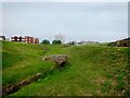
This wall, which does not follow the full length of the Brierdene Burn, protects the bank from possible erosion and gives this part of the dene a more formalised parkland feel. This is part of the Brierdene Wildlife Site which is managed by the Friends of Brierdene, with assistance from North Tyneside Council. It contains some 327 species of trees, wild flowers, grasses and herbs and in total some 126 species of birds, 21 species of butterfly, 15 species of bumblebees and 165 different species of moths have at some time been seen here. For a selection of detailed free to download walking routes in the area visit www.northtynesidewalks.co.uk
Image: © Geoff Holland
Taken: 11 Apr 2020
0.10 miles
7
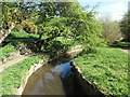
Bridge over the Brierdene Burn, Whitley Bay
This is the highest of six small bridges which cross the Brierdene Burn as it passes through the Brierdene an area which is managed by Friends of Brierdene see www.friendsofbrierdene.org.uk with assistance from North Tyneside Council. For a selection of detailed free to download walking routes in the area visit www.northtynesidewalks.co.uk
Image: © Geoff Holland
Taken: 5 Jul 2019
0.11 miles
8

Bridge over the Brierdene Burn, Whitley Bay
This is the second highest of six small bridges which cross the Brierdene Burn as it passes through the Brierdene an area which is managed by Friends of Brierdene see www.friendsofbrierdene.org.uk with assistance from North Tyneside Council. For a selection of detailed free to download walking routes in the area visit www.northtynesidewalks.co.uk
Image: © Geoff Holland
Taken: 5 Jul 2019
0.11 miles
9
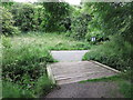
Footpath, Brierdene, Whitley Bay
This footpath descends from the large grassy area above the Brierdene Burn to the burn itself and is one of a number of such access points. This whole area was previously part of Whitley Bay Golf Links, as shown on the 1920 Ordnance Survey Six-Inch map of the area, and is now the Brierdene Wildlife Site. The site is managed by the Friends of Brierdene, with assistance from North Tyneside Council, and contains some 327 species of trees, wild flowers, grasses and herbs. In total some 126 species of birds, 21 species of butterfly, 15 species of bumblebees and 165 different species of moths have at some time been seen here. For a selection of detailed free to download walking routes in the area visit www.northtynesidewalks.co.uk
Image: © Geoff Holland
Taken: 11 Apr 2020
0.11 miles
10
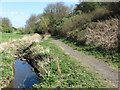
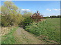
Footpath alongside Brierdene Burn, Whitley Bay
This footpath follows the burn on its southern banks and is slightly downstream from the area shown at https://www.geograph.org.uk/photo/6440104. This is part of the Brierdene Wildlife Site which is managed by the Friends of Brierdene, with assistance from North Tyneside Council. It contains some 327 species of trees, wild flowers, grasses and herbs and in total some 126 species of birds, 21 species of butterfly, 15 species of bumblebees and 165 different species of moths have at some time been seen here. For a selection of detailed free to download walking routes in the area visit www.northtynesidewalks.co.uk
Image: © Geoff Holland
Taken: 11 Apr 2020
0.11 miles