IMAGES TAKEN NEAR TO
Earsdon Road, WHITLEY BAY, NE25 9NQ
Introduction
This page details the photographs taken nearby to Earsdon Road, NE25 9NQ by members of the Geograph project.
The Geograph project started in 2005 with the aim of publishing, organising and preserving representative images for every square kilometre of Great Britain, Ireland and the Isle of Man.

There are currently over 7.5m images from over14,400 individuals and you can help contribute to the project by visiting https://www.geograph.org.uk
Image Map (Loading...)


Getting Data...Please wait
Leaflet Map data © OpenStreetMap
Images are licensed for reuse under creativecommons.org/licenses/by-sa/2.0
Notes
- Clicking on the map will re-center to the selected point.
- The higher the marker number, the further away the image location is from the centre of the postcode.
Image Listing (19 Images Found)
Images are licensed for reuse under creativecommons.org/licenses/by-sa/2.0
Image
Details
Distance
1
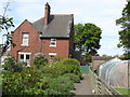
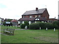
Newsteads Farmhouse, Earsdon Road, West Monkseaton
This brick building, which first appeared on the 1920 edition of the Ordnance Survey Six-Inch map of the area, once formed part of Newsteads Farm and then the local Council's (Whitley Bay Borough Council and North Tyneside Council) nursery garden but has now been converted into two separate dwellings. Whilst the building itself falls within this Grid Square, the garden lies within Grid Square NZ3371. For a selection of detailed free to download walking routes in the area visit www.northynesidewalks.co.uk
Image: © Geoff Holland
Taken: 5 May 2020
0.05 miles
2
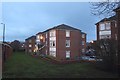
Flats off Rosemount Way, West Monkseaton
Blocks of flats beside Rosemount Way in West Monkseaton.
Image: © Graham Robson
Taken: 24 Nov 2018
0.05 miles
3
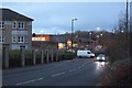
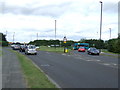
Rosemount Way, West Monkseaton
A street in West Monkseaton. A large Sainsbury's supermarket is visible further down the street.
Image: © Graham Robson
Taken: 24 Nov 2018
0.07 miles
4
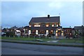
The Beacon, Earsdon Road, West Monkseaton
A pub situated off Earsdon Road in West Monkseaton.
Image: © Graham Robson
Taken: 24 Nov 2018
0.09 miles
6
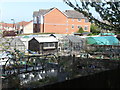
Allotments adjoining West Monkseaton Metro Station
When the 1920 Ordnance Survey Six-Inch map of the area was published, this area formed part of Newsteads Farm. Whilst the history of allotments goes back many centuries, it was not until the Small Holdings and Allotments Act 1908 came into force that local authorities were legally obliged to provide "sufficient allotments according to demand". This duty was further extended with the passing of the Land Settlement Facilities Act 1919 with the rights of allotment holders being strengthened by the Allotments Act 1922. However, the most important change was introduced when the Allotments Act 1925 established statutory allotments which local authorities could not sell off or covert to other uses without Ministerial consent. For a selection of detailed free to download walking routes in the area visit www.northtynesidewalks.co.uk
Image: © Geoff Holland
Taken: 19 Apr 2020
0.13 miles
7
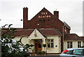
The Beacon Public House, West Monkseaton
An upmarket pub just up the road from Sainsbury's!
Image: © Alan Fearon
Taken: 14 Nov 2005
0.14 miles
8
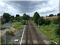
Metro lines heading west
From West Monkseaton Metro Station.
Image: © JThomas
Taken: 3 Aug 2013
0.14 miles
10

West Monkseaton Metro station, Tyne & Wear
Opened in 1933 by the London & North Eastern Railway on the North Tyneside loop line from Newcastle to Tynemouth, this station was converted to Metro operation in 1980.
View south west towards Shiremoor and Newcastle.
Image: © Nigel Thompson
Taken: 17 Sep 2010
0.15 miles