IMAGES TAKEN NEAR TO
Hillcrest, WHITLEY BAY, NE25 9AD
Introduction
This page details the photographs taken nearby to Hillcrest, NE25 9AD by members of the Geograph project.
The Geograph project started in 2005 with the aim of publishing, organising and preserving representative images for every square kilometre of Great Britain, Ireland and the Isle of Man.

There are currently over 7.5m images from over14,400 individuals and you can help contribute to the project by visiting https://www.geograph.org.uk
Image Map (Loading...)


Getting Data...Please wait
Leaflet Map data © OpenStreetMap
Images are licensed for reuse under creativecommons.org/licenses/by-sa/2.0
Notes
- Clicking on the map will re-center to the selected point.
- The higher the marker number, the further away the image location is from the centre of the postcode.
Image Listing (29 Images Found)
Images are licensed for reuse under creativecommons.org/licenses/by-sa/2.0
Image
Details
Distance
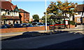
1
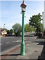
Sewer Gas Lamp, Deneholm, Monkseaton
This is one of ten surviving Sewer Gas Lamps erected in the Whitley Bay and Monkseaton area between 1900 and 1910 and is Grade II Listed. Although these lamps were once common features of our streets they are increasingly rare, and those combined with sewer vents are rarer still. Despite the loss of one ornamental bracket and part of the glass lantern, this is a relatively intact example and, not withstanding its humble nature, it is an attractive gas standard with a fluted cast-iron base and ornamental brackets. The lamp is also an example of a technology which once transformed everyday existence. For a selection of detailed free to download walking routes in the area visit www.northtynesidewalks.co.uk
Image: © Geoff Holland
Taken: 5 May 2020
0.05 miles
2
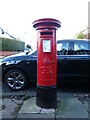
Post Box, Hillcrest, Monkseaton
This post box dates from the reign of King George V (1910-1936) and can be distinguished from post boxes dating from the reign of King George VI (1936-1952) by the more simple cipher and the lack of the Roman Numeral V. For a selection of detailed free to download walking routes in the area visit www.northtynesidewalks.co.uk
Image: © Geoff Holland
Taken: 18 Jan 2021
0.06 miles
3
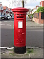
Post Box, Highbury, Monkseaton
This post box, which stands at the junction with Windsor Road, dates from the reign of Edward VII (1901-1910). The earliest Edwardian boxes (1901-1904) were modified from the last Victorian boxes but midway through his reign the elaborate scroll cipher began to appear on the post boxes. For a selection of detailed free to download walking routes in the area visit www.northtynesidewalks.co.uk
Image: © Geoff Holland
Taken: 25 Feb 2021
0.13 miles
4
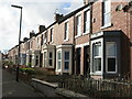
Princes Gardens, Monkseaton
Built sometime between the publication of the second edition of the Ordnance Survey Six-Inch map of the area in 1898 and the 1913 revision of the map published in 1920, Princes Gardens was once the home of legendry Tyneside comedian Bobby Thompson. Moving here in 1961, Bobby occupied number 20 until his death, at the age of 76, in 1988. Many famous visitors passed through the front door of number 20, the most famous being Mohammed Ali, boxing Heavyweight World Champion. For a selection of detailed free to download walking routes in the area visit www.northtynesidewalks.co.uk
Image: © Geoff Holland
Taken: 25 Feb 2021
0.13 miles
5
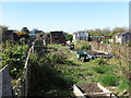
Allotments near Langdale, Monkseaton
These allotments are bounded to the north by Whitley Bay High School which officially opened on the 07th December 1963, to the east by the old Avenue Branch of the Blyth & Tyne Railway, to the south by Langdale and to the west by Alder Grove. Whilst the history of allotments goes back many centuries, it was not until the Small Holdings and Allotments Act 1908 came into force that local authorities were legally obliged to provide "sufficient allotments according to demand". This duty was further extended with the passing of the Land Settlement Facilities Act 1919 with the rights of allotment holders being strengthened by the Allotments Act 1922. However, the most important change was introduced when the Allotments Act 1925 established statutory allotments which local authorities could not sell off or covert to other uses without Ministerial consent. For a selection of detailed free to download walking routes in the area visit www.northtynesidewalks.co.uk
Image: © Geoff Holland
Taken: 20 Apr 2020
0.15 miles
6
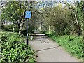
Sign near Churchill Playing Fields, Monkseaton
This sign points towards the housing estate which lies between the Tyne & Wear Metro light railway line & Whitley Bay High & Valley Gardens Middle Schools. The narrow link path is not shown on the 1:25K Ordnance Survey map of the area as it squeezes between the Allotment Gardens and the most northerly end property in Langdale. The track, which runs from Monkseaton in the south to The Avenue near Seaton Delaval Hall in the north, is now a well-used recreational path following the course of the old Avenue Branch of the Blyth & Tyne Railway. For a selection of detailed free to download walking routes in the area visit www.northtynesidewalks.co.uk
Image: © Geoff Holland
Taken: 11 Apr 2020
0.16 miles
7
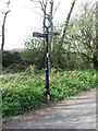
Sign near Churchill Playing Fields
This sign, which lies on the course of the old Avenue Branch of the Blyth & Tyne Railway, points the way to Holywell Dene to the north and Monkseaton Metro Station to the south. For a selection of detailed free to download walking routes in the area visit www.northtynesidewalks.co.uk
Image: © Geoff Holland
Taken: 5 Apr 2020
0.18 miles
8
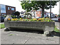
Cattle Trough, Monkseaton
This cattle trough, which is now used for the display of flowers, was erected by the Whitley & Monkseaton Urban District Council in July 1927 at which time there were still a number of farms nearby. The Metropolitan Drinking Fountain and Cattle Trough Association was an association set up in London in 1859 by Samuel Gurney, a Member of Parliament and philanthropist, and Edward Thomas Wakefield, a barrister, to provide free drinking water.
Originally called the Metropolitan Free Drinking Fountain Association, it changed its name to include cattle troughs in 1867. In 2011, as the Drinking Fountain Association, it began to support the Find-a-Fountain campaign to map the UK's drinking water fountains. For a selection of detailed free to download walking routes in the area visit www.northtynesidewalks.co.uk
Image: © Geoff Holland
Taken: 5 May 2020
0.19 miles
9
Site of Village Green, Monkseaton 2008
This is the view today of Monkseaton "village green" depicted in the 1957 photograph submitted by Dale Utterson. Taken from a similar location although not actually from the garden of no.1 Chapel Lane. The Ship Inn and the Black Horse are still there but the Co-Op store appears to have been converted into a residential property.
Image: © R J McNaughton
Taken: 16 Oct 2008
0.19 miles
10
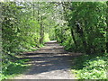
Path near Churchill Playing Fields, Monkseaton
This path stretches from Monkseaton in the south to The Avenue near Seaton Delaval Hall to the north and for most of the way it follows the course of the old Avenue Branch of the Blyth & Tyne Railway. This railway was opened on 31 October 1860 and ran between Hartley (New Hartley) to the north and Whitley Junction (Monkseaton) to the south. At this point the path is following a 1915 re-alignment of the track which was built so as to terminate the line at the new 1915 completed Monkseaton Station. For a selection of detailed free to download walking routes in the area visit www.northtynesidewalks.co.uk
Image: © Geoff Holland
Taken: 11 Apr 2020
0.20 miles