IMAGES TAKEN NEAR TO
Brantwood Avenue, WHITLEY BAY, NE25 8LY
Introduction
This page details the photographs taken nearby to Brantwood Avenue, NE25 8LY by members of the Geograph project.
The Geograph project started in 2005 with the aim of publishing, organising and preserving representative images for every square kilometre of Great Britain, Ireland and the Isle of Man.

There are currently over 7.5m images from over14,400 individuals and you can help contribute to the project by visiting https://www.geograph.org.uk
Image Map
Images are licensed for reuse under creativecommons.org/licenses/by-sa/2.0
Notes
- Clicking on the map will re-center to the selected point.
- The higher the marker number, the further away the image location is from the centre of the postcode.
Image Listing (15 Images Found)
Images are licensed for reuse under creativecommons.org/licenses/by-sa/2.0
Image
Details
Distance
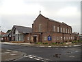
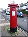
1

Sewer Gas Lamp, Brantwood Avenue, Monkseaton
This is one of ten surviving Sewer Gas Lamps erected in the Whitley Bay and Monkseaton area between 1900 and 1910 and is Grade II Listed. Although these lamps were once common features of our streets they are increasingly rare, and those combined with sewer vents are rarer still. This is an intact example with a complete glass lantern, and not withstanding its humble nature, this is an attractive gas standard with a fluted cast-iron base and ornamental brackets. The lamp is also an example of a technology which once transformed everyday existence. For a selection of detailed free to download walking routes in the area visit www.northtynesidewalks.co.uk
Image: © Geoff Holland
Taken: 5 May 2020
0.00 miles
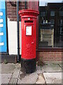
3
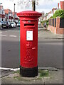
Post Box, Highbury, Monkseaton
This post box, which stands at the junction with Windsor Road, dates from the reign of Edward VII (1901-1910). The earliest Edwardian boxes (1901-1904) were modified from the last Victorian boxes but midway through his reign the elaborate scroll cipher began to appear on the post boxes. For a selection of detailed free to download walking routes in the area visit www.northtynesidewalks.co.uk
Image: © Geoff Holland
Taken: 25 Feb 2021
0.15 miles
4
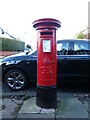
Post Box, Hillcrest, Monkseaton
This post box dates from the reign of King George V (1910-1936) and can be distinguished from post boxes dating from the reign of King George VI (1936-1952) by the more simple cipher and the lack of the Roman Numeral V. For a selection of detailed free to download walking routes in the area visit www.northtynesidewalks.co.uk
Image: © Geoff Holland
Taken: 18 Jan 2021
0.15 miles
5
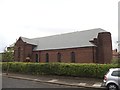
St Andrew's United Reformed Church, Monkseaton
Image: © Bill Henderson
Taken: 10 Jun 2012
0.16 miles
6
Post Box, Oakland Road, Monkseaton
This post box dates from the reign of Queen Victoria and stands at the end of Oakland Road. The keen-eyed will note that the box does not bear a royal cypher on the door nor do the words 'Post Office' appear anywhere on the box. It also has a high aperture. This type of box is known as an 'Anonymous' box and first appeared in 1879 and was produced until 1883. As the area on which the box is located was farmland until the early part of the 20th century, this box must have been relocated here at some subsequent date. For a selection of detailed free to download walking routes in the area visit www.northtynesidewalks.co.uk
Image: © Geoff Holland
Taken: 30 Jan 2021
0.16 miles
7
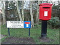
Post Box, Newsteads Drive/Muirfield, West Monkseaton
This modern (1990s) pedestal post box stands on the corner of Newsteads Drive and Muirfield. A larger post box lies approximately 320 metres away on the corner of Newsteads Drive/Chathill Close https://www.geograph.org.uk/photo/6464806. For a selection of detailed free to download walking routes in the area visit www.northtynesidewalks.co.uk
Image: © Geoff Holland
Taken: 18 Jan 2021
0.18 miles
8
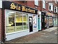
Parade of Retail Units, Cauldwell Lane, Monkseaton
This small parade of retail units includes, as seen in this photograph, Sia Barbers, Primrose Massage & Beauty and Monkseaton Nail Bar & Beauty.
Image: © Geoff Holland
Taken: 5 Nov 2024
0.20 miles
9
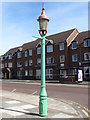
Sewer Gas Lamp, Front Street, Monkseaton
This is one of ten surviving Sewer Gas Lamps erected in the Whitley Bay and Monkseaton area between 1900 and 1910 and is Grade II Listed. Although these lamps were once common features of our streets they are increasingly rare, and not withstanding its humble nature, it is an attractive gas standard with a cast-iron base, curved glass lantern and ladder rest at top. The lamp is also an example of a technology which once transformed everyday existence. The panel on the base states: 'Webb Lamp Company Ltd. Birmingham' and 'J.E.Webb's Patent Sewer Gas Destructer'. For a selection of detailed free to download walking routes in the area visit www.northtynesidewalks.co.uk
Image: © Geoff Holland
Taken: 5 May 2020
0.21 miles
10
Post Box, Front Street, Monkseaton
This post box dates from the reign of Elizabeth II and stands on Front Street next to a Fish & Chip Shop. The nearest Post Office is 125 metres away at 25 Cauldwell Lane. For a selection of detailed free to download walking routes in the area visit www.northtynesidewalks.co.uk
Image: © Geoff Holland
Taken: 18 Jan 2021
0.21 miles