
IMAGES TAKEN NEAR TO
Chapel Lane, WHITLEY BAY, NE25 8AB
Introduction
This page details the photographs taken nearby to Chapel Lane, NE25 8AB by members of the Geograph project.
The Geograph project started in 2005 with the aim of publishing, organising and preserving representative images for every square kilometre of Great Britain, Ireland and the Isle of Man.

There are currently over 7.5m images from over14,400 individuals and you can help contribute to the project by visiting https://www.geograph.org.uk
Image Map
Images are licensed for reuse under creativecommons.org/licenses/by-sa/2.0
Notes
- Clicking on the map will re-center to the selected point.
- The higher the marker number, the further away the image location is from the centre of the postcode.
Image Listing (39 Images Found)
Images are licensed for reuse under creativecommons.org/licenses/by-sa/2.0
Image
Details
Distance
1
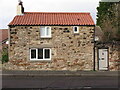
Garden Cottage, Bygate Road, Monkseaton
This stone building, which is clearly shown on the first Ordnance Survey Six-Inch map of the area published in 1865, was described in the 'Monkseaton Conservation Area Character Appraisal', published by North Tyneside Council in October 2006 as, "an important example of the more diminutive outhouses and cottages which must have characterised Bygate Road, Back Lane and The Fold before suburbanisation". During the 1840s it was said to have been known known as "Ramsay's Fort" because the owner, a certain Robert Ramsay, was supposed to have two imitation cannons on the roof, with the intention of frightening away the French should they ever invade". For a selection of detailed free to download walking routes in the area visit www.northtynesidewalks.co.uk
Image: © Geoff Holland
Taken: 18 Jan 2021
0.05 miles
2
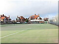
Beverley Park Lawn Tennis Club, Beverley Road, Monkseaton
Beverley Park Lawn Tennis Club was founded on 20th February 1920 and has four all weather courts and a clubhouse with a kitchen and changing facilities including toilets and a shower area. The club also has disabled access with a disabled toilet on site. The Club were named Tennis Club of the Year at the Northumberland Lawn Tennis Association Awards 2018. For a selection of detailed free to download walking routes in the area visit www.northtynesidewalks.co.uk
Image: © Geoff Holland
Taken: 18 Jan 2021
0.09 miles
3
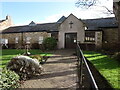
Monkseaton Methodist Church, 35 Front Street, Monkseaton
Originally this single-storey stone-built property formed part of the outbuildings (byre, stable and turnip house) of Monkseaton Village Farm dating back to at least the 18th century. The building first came into use as a place of worship in 1899 when it was purchased by local dignitary and benefactor Col. T.W. Elliott, of nearby Monkseaton Cottage https://www.geograph.org.uk/photo/6765202, who converted the building into an Anglican church which in about 1913 came into the possession of the Methodist Church. For a selection of detailed free to download walking routes in the area visit www.northtynesidewalks.co.uk
Image: © Geoff Holland
Taken: 25 Feb 2021
0.09 miles
4
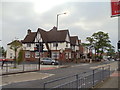
The Black Horse Public House, Monkseaton
Image: © Bill Henderson
Taken: 10 Jun 2012
0.10 miles
5
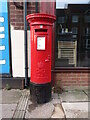
Post Box, Front Street, Monkseaton
This post box dates from the reign of Elizabeth II and stands on Front Street next to a Fish & Chip Shop. The nearest Post Office is 125 metres away at 25 Cauldwell Lane. For a selection of detailed free to download walking routes in the area visit www.northtynesidewalks.co.uk
Image: © Geoff Holland
Taken: 18 Jan 2021
0.10 miles
6
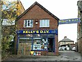
Kelly's D.I.Y., 31 Front Street, Monkseaton
A Monkseaton institution seemingly forever, Kelly's is an 'Aladdin's Cave' of DIY essentials including a cut-to-size timber supply service, along with a broad selection of electrical, plumbing, decorating and gardening materials and a whole lot more.
Image: © Geoff Holland
Taken: 30 Oct 2024
0.10 miles
7
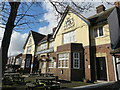
The Black Horse Inn, Front Street, Monkseaton
When writing in his 1893-published book, 'Historical Notes on Cullercoats Whitley and Monkseaton', William Weaver Tomlinson said that in 1827, "the village supported three inns-the Black Horse, Three Horse Shoes and the Ship". The original Black Horse Inn was built in 1793 as a two-storey stone building, with a third floor being added later. In 1936 permission was granted for the building to demolished and replaced by the current building. For a selection of detailed free to download walking routes in the area visit www.northtynesidewalks.co.uk
Image: © Geoff Holland
Taken: 25 Feb 2021
0.11 miles
8
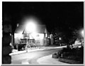
Black Horse, Monkseaton (1958)
An artistic night-time shot of the Black Horse in Monkseaton. Taken from the upstairs window of 1 Chapel Lane by my father Terry Utterson in 1958.
Image: © Dale Utterson
Taken: Unknown
0.11 miles
9
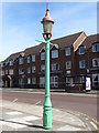
Sewer Gas Lamp, Front Street, Monkseaton
This is one of ten surviving Sewer Gas Lamps erected in the Whitley Bay and Monkseaton area between 1900 and 1910 and is Grade II Listed. Although these lamps were once common features of our streets they are increasingly rare, and not withstanding its humble nature, it is an attractive gas standard with a cast-iron base, curved glass lantern and ladder rest at top. The lamp is also an example of a technology which once transformed everyday existence. The panel on the base states: 'Webb Lamp Company Ltd. Birmingham' and 'J.E.Webb's Patent Sewer Gas Destructer'. For a selection of detailed free to download walking routes in the area visit www.northtynesidewalks.co.uk
Image: © Geoff Holland
Taken: 5 May 2020
0.11 miles
10
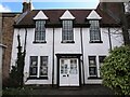
Friends Meeting House, Front Street, Monkseaton
This is an interesting mid to late Georgian survival which was extended and adapted in the early 20th century, initially for residential use. It is thought that the property, which still retains its original thick stone walls, originated as a single storey cottage for farmworkers. The early 20th century century alterations illustrate its transformation to a higher status private dwelling and then to a Quaker Meeting House in 1910. For a selection of detailed free to download walking routes in the area visit www.northtynesidewalks.co.uk
Image: © Geoff Holland
Taken: 25 Feb 2021
0.11 miles