IMAGES TAKEN NEAR TO
Eslington Terrace, NEWCASTLE UPON TYNE, NE2 4RJ
Introduction
This page details the photographs taken nearby to Eslington Terrace, NE2 4RJ by members of the Geograph project.
The Geograph project started in 2005 with the aim of publishing, organising and preserving representative images for every square kilometre of Great Britain, Ireland and the Isle of Man.

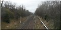
There are currently over 7.5m images from over14,400 individuals and you can help contribute to the project by visiting https://www.geograph.org.uk
Image Map
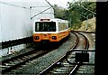
Images are licensed for reuse under creativecommons.org/licenses/by-sa/2.0
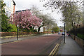
Notes
- Clicking on the map will re-center to the selected point.
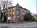
- The higher the marker number, the further away the image location is from the centre of the postcode.
Image Listing (162 Images Found)
Images are licensed for reuse under creativecommons.org/licenses/by-sa/2.0
Image
Details
Distance
1
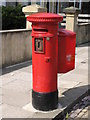
"Anonymous" (Victorian) postbox, Eslington Terrace
The low posting aperture dates this postbox to 1883-87; for a nearby example of a high aperture "anonymous" postbox see Image The location of this postbox is shown in Image and Image
Image: © Mike Quinn
Taken: 29 Apr 2009
0.01 miles
2
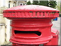
"Anonymous" (Victorian) postbox, Eslington Terrace - aperture
See Image The original aperture has been crudely enlarged on its right hand side.
Image: © Mike Quinn
Taken: 2 May 2013
0.01 miles
3
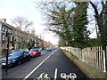
View along Elsington Terrace, Jesmond
This street is in the Brandling Village area of the suburb, and was built as superior middle class housing in the late 19th century. View is looking north, with the Metro line on the right.
Image: © Robert Graham
Taken: 10 Feb 2020
0.03 miles
4
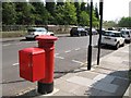
Eslington Terrace (2)
Shows the location of Image
Image: © Mike Quinn
Taken: 29 Apr 2009
0.03 miles
5
Tyne and Wear Metro north of Jesmond Station
This section was originally opened by the Blyth and Tyne Railway on 27 June 1864 as part of its extension from Holywell to Newcastle New Bridge Street.
The line was closed 23 January 1978 for conversion to Metro and re-opened 11 August 1980. The diversion to the new Metro station can be seen to the right.
Image: © Anthony Foster
Taken: 20 Feb 2013
0.03 miles
6
Elsington Tower
This imposing building occupies the corner between Elsington Terrace and Elsington Road. It was built in the late 19th century, originally as a large town house I believe. Later it was a private Girls School and is now divided into flats.
Image: © Robert Graham
Taken: 10 Feb 2020
0.04 miles
7
Jesmond Metro Station
A Tyne and Wear Metro train leaving Jesmond Station with a train for Benton on the Coast Loop. The original Jesmond station on the old electric Tyneside suburban lines still exists behind the cutting on the right.
Image: © Bob Walters
Taken: 6 Oct 1987
0.05 miles
8
Eskdale Terrace
This end of the road has several institutional and educational buildings. The appearance is improved by blossom.
Image: © Bill Boaden
Taken: 20 Apr 2017
0.05 miles
9
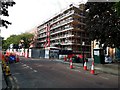
Construction site, Eskdale Terrace, Brandling Village, Jesmond, Newcastle upon Tyne
A development of flats under construction on Eskdale Terrace in Brandling Village.
Image: © Graham Robson
Taken: 15 Jun 2020
0.06 miles
10
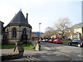
Elsington Road, Jesmond
This short road forms the centre of the Brandling Village area of the suburb of Jesmond. On the left here is the Parish Church, with the Royal Grammar School in the centre and Lifton House on the right. These are all notable late 19th century buildings.
Image: © Robert Graham
Taken: 10 Feb 2020
0.07 miles