IMAGES TAKEN NEAR TO
Drift Gardens, BLYTH, NE24 5BP
Introduction
This page details the photographs taken nearby to Drift Gardens, NE24 5BP by members of the Geograph project.
The Geograph project started in 2005 with the aim of publishing, organising and preserving representative images for every square kilometre of Great Britain, Ireland and the Isle of Man.

There are currently over 7.5m images from over14,400 individuals and you can help contribute to the project by visiting https://www.geograph.org.uk
Image Map
Images are licensed for reuse under creativecommons.org/licenses/by-sa/2.0
Notes
- Clicking on the map will re-center to the selected point.
- The higher the marker number, the further away the image location is from the centre of the postcode.
Image Listing (19 Images Found)
Images are licensed for reuse under creativecommons.org/licenses/by-sa/2.0
Image
Details
Distance
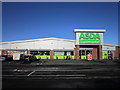
2
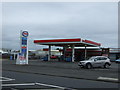
ASDA supermarket, Cowpen Road, Blyth
An ASDA supermarket on the north side of Cowpen Road. It is located next to a branch of Lidl.
Image: © Graham Robson
Taken: 13 Aug 2022
0.05 miles
3
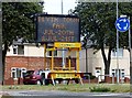
Matrix sign in Blyth
An advisory sign regarding The Town Fair
Image: © David Clark
Taken: 16 Jul 2013
0.08 miles
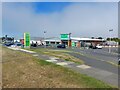
4
Retail and industrial area north of Blyth town centre
With the A193 Cowpen Road in the background, this is the mixed retail/industrial unit area to the immediate north west of the town centre of Blyth.
Image: © Grahame Jenkins
Taken: 21 Jan 2006
0.08 miles
5
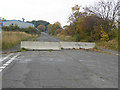
Road closure, Crawford Street
Two large concreete slabs form a chicane which prevents cars driving through but allows cyclists following the National Cycle Network route 1 (Coast and Castles).
Image: © Oliver Dixon
Taken: 26 Oct 2015
0.09 miles
6
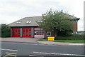
Blyth fire station
Blyth fire station, Cowpen Road, Blyth, Northumberland
Image: © Kevin Hale
Taken: 3 Aug 2010
0.10 miles
7
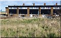
The backs of houses on Chestnut Avenue
Adjacent to the bund.
Image: © Russel Wills
Taken: 22 Feb 2016
0.10 miles
8
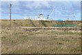
Waste land behind the bund
The superstructure of a ship at the jetties just visible.
Image: © Russel Wills
Taken: 22 Feb 2016
0.15 miles
10
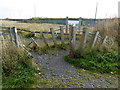
Entrance to Bates Minewater Treatment Scheme
Access control at the start of a path leading to the reedbeds where contaminated minewater from the old Bates Colliery is filtered.
Image: © Oliver Dixon
Taken: 26 Oct 2015
0.18 miles