IMAGES TAKEN NEAR TO
South View, BLYTH, NE24 3RA
Introduction
This page details the photographs taken nearby to South View, NE24 3RA by members of the Geograph project.
The Geograph project started in 2005 with the aim of publishing, organising and preserving representative images for every square kilometre of Great Britain, Ireland and the Isle of Man.

There are currently over 7.5m images from over14,400 individuals and you can help contribute to the project by visiting https://www.geograph.org.uk
Image Map
Images are licensed for reuse under creativecommons.org/licenses/by-sa/2.0
Notes
- Clicking on the map will re-center to the selected point.
- The higher the marker number, the further away the image location is from the centre of the postcode.
Image Listing (17 Images Found)
Images are licensed for reuse under creativecommons.org/licenses/by-sa/2.0
Image
Details
Distance
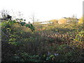
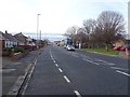
2
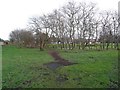
Park, Newsham
Once a golf course with the club house situated around here, the area is being developed for housing. On the left of the picture is the site of the railway which served the South Harbour and Cowpen Colliery.
Image: © Richard Webb
Taken: 26 Jan 2019
0.06 miles
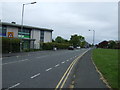
3
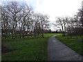
Path, Newsham
Once a path across a golf course, the area has been developed for housing. The 1982 1:50,000 map still shows a club house here.
Image: © Richard Webb
Taken: 26 Jan 2019
0.07 miles