IMAGES TAKEN NEAR TO
Allendale Road, BLYTH, NE24 3EG
Introduction
This page details the photographs taken nearby to Allendale Road, NE24 3EG by members of the Geograph project.
The Geograph project started in 2005 with the aim of publishing, organising and preserving representative images for every square kilometre of Great Britain, Ireland and the Isle of Man.

There are currently over 7.5m images from over14,400 individuals and you can help contribute to the project by visiting https://www.geograph.org.uk
Image Map
Images are licensed for reuse under creativecommons.org/licenses/by-sa/2.0
Notes
- Clicking on the map will re-center to the selected point.
- The higher the marker number, the further away the image location is from the centre of the postcode.
Image Listing (36 Images Found)
Images are licensed for reuse under creativecommons.org/licenses/by-sa/2.0
Image
Details
Distance
1
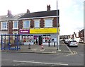
Wensleydale Convenience Store
On the corner of Dent Street and Wensleydale Terrace, Blyth.
Image: © Russel Wills
Taken: 22 Feb 2016
0.06 miles
7
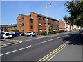
Flats in Wensleydale Terrace, Blyth
The flats are built on the route of the southern railway line into Blyth harbour and which crossed the road here by means of an overbridge.
Image: © John Lucas
Taken: 16 Aug 2016
0.10 miles
9
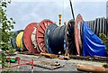
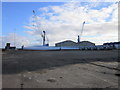
There must be an enormous sewing machine around here!
Cable laying ships operate out of the Port of Blyth, presumably supplying the offshore wind farms.
Image: © Leanmeanmo
Taken: 17 Sep 2023
0.10 miles
10
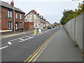
Coast and Castles route through Blyth
National Cycle Network route 1 (Coast and Castles) here follows the footway along the B1329 on the east side of Blyth. The high fence on the right demarcates the Dock area.
Image: © Oliver Dixon
Taken: 26 Oct 2015
0.11 miles