IMAGES TAKEN NEAR TO
Davidsons Cottages, NEWCASTLE UPON TYNE, NE2 3PD
Introduction
This page details the photographs taken nearby to Davidsons Cottages, NE2 3PD by members of the Geograph project.
The Geograph project started in 2005 with the aim of publishing, organising and preserving representative images for every square kilometre of Great Britain, Ireland and the Isle of Man.

There are currently over 7.5m images from over14,400 individuals and you can help contribute to the project by visiting https://www.geograph.org.uk
Image Map
Images are licensed for reuse under creativecommons.org/licenses/by-sa/2.0
Notes
- Clicking on the map will re-center to the selected point.
- The higher the marker number, the further away the image location is from the centre of the postcode.
Image Listing (61 Images Found)
Images are licensed for reuse under creativecommons.org/licenses/by-sa/2.0
Image
Details
Distance
1
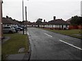
Davidson Cottages, Gosforth, Newcastle upon Tyne
A cul-de-sac of bungalows built as North Eastern Railway Cottage Homes in 1929.
Image: © Graham Robson
Taken: 11 Jun 2020
0.00 miles
2
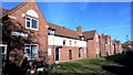
Davidson Cottages, High West Jesmond
North Eastern Railway cottages dating from 1928, originally for retired railwaymen. Now run by the Railway Housing Trust who have relaxed their eligibility rules, but applicants need to be 50+ see; http://www.railwayha.co.uk/
Image: © Chris Morgan
Taken: 9 Mar 2018
0.02 miles
3
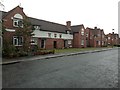
North Eastern Railway Cottage Homes, Woodthorne Road, Gosforth
A row of cottages built as North Eastern Railway Cottage Homes. A date stone in the wall of the terrace dates it to 1928.
Image: © Graham Robson
Taken: 11 Jun 2020
0.03 miles
4
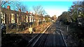
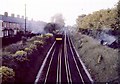
Ilford Road Metro station from Moorfield bridge
This picture is taken from the overbridge on Moorfield and shows the embankment on both sides of the line. It should be compared with this picture I took in 1964: https://www.geograph.org.uk/photo/5663710
Spot the difference.
Image: © Chris Morgan
Taken: 8 Jan 2018
0.05 miles
5

View north up Ilford Road
View from outside Ilford Road Metro Station. The terraced streets here date from the early 20th century when this northern part of Jesmond was developed.
Image: © Robert Graham
Taken: 15 Jul 2024
0.06 miles
6
Embankment fires between Ilford Road and Albury Road, Newcastle
This picture is taken from the overbridge on Moorfield and shows the embankment on both sides of the line had been set alight by sparks from a steam hauled freight train that had passed earlier that spring evening.
This is now the position of the Ilford Road Metro station, see modern picture; https://www.geograph.org.uk/photo/5663720
A 4 coach Tyneside commuter multiple unit electric has just passed and is roughly where Metro platforms now stand. These trains used to run in 2, 4, 6 or 8 coach sets. At busy summer weekends a special pram coach was often added to 6 coach trains to help get young families to the coast. The pram coaches were older coaches retained from the previous style stock, similar to those used on the South Tyne line to South Shields.
Not too long after this photo was taken it was decided not to replace these old LNER electric units and to replace them with DMUs. They were not to operate as frequent a service, and were noisier. Usage dropped sharply. Amazingly, the finance was assembled to build the Metro system. This part of the track retained the old wooden sleepers, still showing traces of where the third rail had been supported, until the track was relaid with concrete sleepers in August 2013.
This part of Newcastle is called High West Jesmond. Due to its proximity to Gosforth fire engines were despatched from both the Northumberland fire station at Gosforth and Newcastle Central fire station. Usually the Gosforth brigade would have the fire out before the Newcastle engine arrived. On this day there was enough work for both!
The Northumberland crew are working in heavy helmets. The Newcastle crew are bare headed.
More about the Tyneside electrics at; www.lner.info/locos/Electric/ner_tyneside.shtml
Image: © Chris Morgan
Taken: 10 May 1964
0.06 miles
7
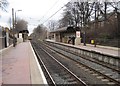
Ilford Road Metro station, Tyne & Wear
Opened in 1980 by the Tyne & Wear Metro on the North Tyneside loop line from Newcastle to Tynemouth.
View north towards South Gosforth and Tynemouth, also the branch to Newcastle Airport.
Image: © Nigel Thompson
Taken: 23 Jan 2010
0.07 miles
8
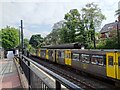
Metro at Ilford Road station
Train standing at the Metro station. New trains are promised to begin introductions later this year (2024) but this is one of the 40 year old original stock. The station here was purpose built for the metro in 1980. Many of the stations are repurposed British Rail ones but this was a new one.
Image: © Robert Graham
Taken: 15 Jul 2024
0.07 miles
10
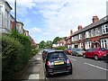
Lodore Road, Jesmond
Part of the grid of terraced streets in this part of Jesmond. These streets were built in the early 20th century as superior houses for the expanding middle classes of Newcastle upon Tyne. Jesmond remains a predominately middle class area.
Image: © Robert Graham
Taken: 15 Jul 2024
0.09 miles