IMAGES TAKEN NEAR TO
Moorfield, NEWCASTLE UPON TYNE, NE2 3NY
Introduction
This page details the photographs taken nearby to Moorfield, NE2 3NY by members of the Geograph project.
The Geograph project started in 2005 with the aim of publishing, organising and preserving representative images for every square kilometre of Great Britain, Ireland and the Isle of Man.

There are currently over 7.5m images from over14,400 individuals and you can help contribute to the project by visiting https://www.geograph.org.uk
Image Map
Images are licensed for reuse under creativecommons.org/licenses/by-sa/2.0
Notes
- Clicking on the map will re-center to the selected point.
- The higher the marker number, the further away the image location is from the centre of the postcode.
Image Listing (67 Images Found)
Images are licensed for reuse under creativecommons.org/licenses/by-sa/2.0
Image
Details
Distance
1
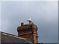
Look out position
A Herring Gull on a chimney pot on Honister Avenue in Jesmond. Maybe looking for a snack to swoop down on.
Image: © Robert Graham
Taken: 15 Jul 2024
0.02 miles
2
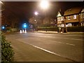
Junction of Jesmond Dene Road and Moorfield
In Jesmond.
Image: © Stephen Sweeney
Taken: 15 Jan 2009
0.03 miles
3
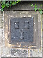
Old Boundary Marker
Estate Boundary Marker set in a stone wall at the junction of Jesmond Dene Road and Moorfield Road, Newcastle upon Tyne. The arms of Newcastle are displayed in relief on its face, marking the boundary of the Town Moor. Grade II Listed https://historicengland.org.uk/listing/the-list/list-entry/1024851.
Milestone Society National ID: NB_NEWC04em
Image: © Mike Rayner
Taken: 22 Jul 2019
0.04 miles
4
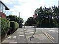
Bridge over the Metro
Moorfield in Jesmond with the junction with Ilford Road ahead and then the bridge over the Metro railway track.
Image: © Robert Graham
Taken: 15 Jul 2024
0.05 miles
5
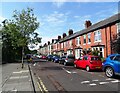
Terraced houses on Ilford Road
Terraced street beside Ilford Road Metro station in Jesmond. This northern part of Jesmond was developed in Edwardian times; the early 20th century.
Image: © Robert Graham
Taken: 15 Jul 2024
0.06 miles
7
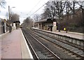
Ilford Road Metro station, Tyne & Wear
Opened in 1980 by the Tyne & Wear Metro on the North Tyneside loop line from Newcastle to Tynemouth.
View north towards South Gosforth and Tynemouth, also the branch to Newcastle Airport.
Image: © Nigel Thompson
Taken: 23 Jan 2010
0.07 miles
8
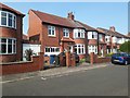
Houses, Crossway, Jesmond, Newcastle upon Tyne
Semi-detached houses on Crossway in Jesmond.
Image: © Graham Robson
Taken: 24 Jun 2020
0.08 miles
9
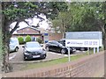
The Newcastle Clinic
The principal facility in the Newcastle Clinic is the flatbed MRI scanner, the only one in the north of the country including Scotland. Not only is this available for private patients, but is used by the NHS to refer patients who are obese or claustrophobic or otherwise unable to cope with being scanned in the usual "tunnel" MRI.
The building also houses the Newcastle Sportsinjury Clinic which provides physiotherapy and other services.
Image: © Oliver Dixon
Taken: 17 Nov 2017
0.08 miles
10
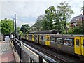
Metro at Ilford Road station
Train standing at the Metro station. New trains are promised to begin introductions later this year (2024) but this is one of the 40 year old original stock. The station here was purpose built for the metro in 1980. Many of the stations are repurposed British Rail ones but this was a new one.
Image: © Robert Graham
Taken: 15 Jul 2024
0.08 miles