IMAGES TAKEN NEAR TO
Rowan Grove, CRAMLINGTON, NE23 6XT
Introduction
This page details the photographs taken nearby to Rowan Grove, NE23 6XT by members of the Geograph project.
The Geograph project started in 2005 with the aim of publishing, organising and preserving representative images for every square kilometre of Great Britain, Ireland and the Isle of Man.

There are currently over 7.5m images from over14,400 individuals and you can help contribute to the project by visiting https://www.geograph.org.uk
Image Map (Loading...)


Getting Data...Please wait
Leaflet Map data © OpenStreetMap
Images are licensed for reuse under creativecommons.org/licenses/by-sa/2.0
Notes
- Clicking on the map will re-center to the selected point.
- The higher the marker number, the further away the image location is from the centre of the postcode.
Image Listing (16 Images Found)
Images are licensed for reuse under creativecommons.org/licenses/by-sa/2.0
Image
Details
Distance
1
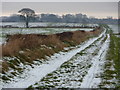
East Cramlington Public Path
View of East Cramlington from the fields to the south on the public path to Seghill/Seaton Delaval.
Image: © Ian Brackenridge
Taken: 24 Dec 2009
0.09 miles
2
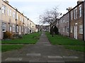
Storey Street, Cramlington
Two of six rows built upon the site of a brickworks adjacent to the Ann Pit of Cramlington Colliery. They do not show up on the 1898 6" map.
Image: © Richard Webb
Taken: 26 Jan 2019
0.13 miles
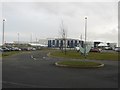
3
Northumbria Specialist Emergency Care Hospital
Opened in 2015, this is England’s first purpose-built specialist emergency care hospital according to an NHS website. It is built on former farmland on the edge of Cramlington. One thing that caught my eye on the website was the parking charges - £1 a day, a pleasant contrast to the usual hospital experience.
In the foreground is a rush filled balancing pond. The story behind the no longer used brick road is unknown.
Image: © Richard Webb
Taken: 26 Jan 2019
0.14 miles
4
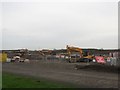
Construction equipment, off the B1326, Cramlington
An array of construction equipment is parked on a building site on which nearly 200 homes are planned to be built. The development, on land next to Cramlington's Northumbria Specialist Emergency Care Hospital, is being built by Miller Homes.
Image: © Graham Robson
Taken: 10 Dec 2016
0.16 miles
5
Northumbria Specialist Emergency Care Hospital
The new hospital opened in 2015 on what was greenfield land on the east edge of Cramlington. The hospital was built to focus on emergency care of patients and as such takes emergency cases from all of the area covered by the Northumbria Healthcare NHS Trust which includes the entire county of Northumberland and also North Tyneside.
Image: © Graham Robson
Taken: 10 Dec 2016
0.16 miles
6
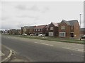
Barley Meadows, East Cramlington
A new development by Miller Homes beside the B1326 in East Cramlington. Image shows the site a year and a half earlier. Construction was continuing on a later phase of the development away from the main road.
Image: © Graham Robson
Taken: 19 Aug 2018
0.18 miles
7
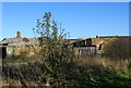
Decaying buildings, East Cramlington Farm
These old ruins are a bit of a puzzle. Are they farm buildings or part of the old colliery which stood near this site?
Image: © Alan Fearon
Taken: 15 Nov 2005
0.18 miles
8
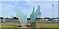
Sculpture at entrance to Cramlington Hospital
Image: © Ron Dixon
Taken: 23 Aug 2016
0.19 miles
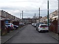
9
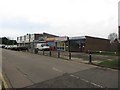
Shops, Clifton Road, Cramlington
A small parade of local shops on Clifton Road in Cramlington.
Image: © Graham Robson
Taken: 10 Dec 2016
0.20 miles