IMAGES TAKEN NEAR TO
Whitelaw Place, CRAMLINGTON, NE23 6HY
Introduction
This page details the photographs taken nearby to Whitelaw Place, NE23 6HY by members of the Geograph project.
The Geograph project started in 2005 with the aim of publishing, organising and preserving representative images for every square kilometre of Great Britain, Ireland and the Isle of Man.

There are currently over 7.5m images from over14,400 individuals and you can help contribute to the project by visiting https://www.geograph.org.uk
Image Map
Images are licensed for reuse under creativecommons.org/licenses/by-sa/2.0
Notes
- Clicking on the map will re-center to the selected point.
- The higher the marker number, the further away the image location is from the centre of the postcode.
Image Listing (4 Images Found)
Images are licensed for reuse under creativecommons.org/licenses/by-sa/2.0
Image
Details
Distance
3
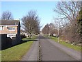
Cycleway, Cramlington
A number of cycleways have been included into the new town of Cramlington. This one, immediately north of Westerlink, follows the line of an old wagonway to a colliery. East of the B1505, a path through to Seghill Image follows the line of the same wagonway.
Image: © Oliver Dixon
Taken: 2 Mar 2010
0.19 miles
4
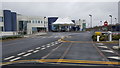
Northumbria Specialist Emergency Care Hospital
Image: © Clive Nicholson
Taken: 22 Mar 2017
0.23 miles