IMAGES TAKEN NEAR TO
Scott Street, CRAMLINGTON, NE23 3AN
Introduction
This page details the photographs taken nearby to Scott Street, NE23 3AN by members of the Geograph project.
The Geograph project started in 2005 with the aim of publishing, organising and preserving representative images for every square kilometre of Great Britain, Ireland and the Isle of Man.

There are currently over 7.5m images from over14,400 individuals and you can help contribute to the project by visiting https://www.geograph.org.uk
Image Map (Loading...)


Getting Data...Please wait
Leaflet Map data © OpenStreetMap
Images are licensed for reuse under creativecommons.org/licenses/by-sa/2.0
Notes
- Clicking on the map will re-center to the selected point.
- The higher the marker number, the further away the image location is from the centre of the postcode.
Image Listing (14 Images Found)
Images are licensed for reuse under creativecommons.org/licenses/by-sa/2.0
Image
Details
Distance
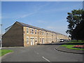
1

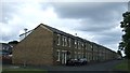
East Hartford and District Community Centre
Image: © Richard Webb
Taken: 26 Jan 2019
0.04 miles
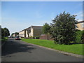
2
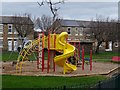
East Hartford Playground
In the corner of a large green in East Hartford.
Image: © Richard Webb
Taken: 26 Jan 2019
0.05 miles

7
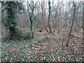
Site of Hartford Colliery
One of the shafts was situated around here in what is now a very established woodland. The colliery closed in 1961.
Image: © Richard Webb
Taken: 26 Jan 2019
0.15 miles
9
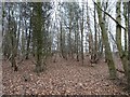
Woodland, East Hartford
Growing on the site of Hartford Colliery which closed in 1961.
Image: © Richard Webb
Taken: 26 Jan 2019
0.15 miles