IMAGES TAKEN NEAR TO
Clintburn Court, CRAMLINGTON, NE23 2SF
Introduction
This page details the photographs taken nearby to Clintburn Court, NE23 2SF by members of the Geograph project.
The Geograph project started in 2005 with the aim of publishing, organising and preserving representative images for every square kilometre of Great Britain, Ireland and the Isle of Man.

There are currently over 7.5m images from over14,400 individuals and you can help contribute to the project by visiting https://www.geograph.org.uk
Image Map
Images are licensed for reuse under creativecommons.org/licenses/by-sa/2.0
Notes
- Clicking on the map will re-center to the selected point.
- The higher the marker number, the further away the image location is from the centre of the postcode.
Image Listing (9 Images Found)
Images are licensed for reuse under creativecommons.org/licenses/by-sa/2.0
Image
Details
Distance
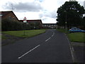
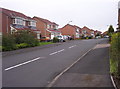
2
Alderley Way, Cramlington
A residential street in the north east corner of Cramlington.
Image: © Graham Robson
Taken: 19 Aug 2018
0.20 miles
4
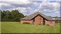
Church of the Nazerene
Cramlington Community Church.
Image: © Richard Webb
Taken: 17 Aug 2019
0.23 miles
5
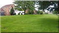
Dunsdale Drive, Cramlington
There is a strip of dull lawn between the houses and distribution road.
Image: © Richard Webb
Taken: 17 Aug 2019
0.24 miles
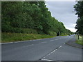
6
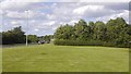
Horton Drive
A distribution road in Cramlington with the usual sterile mown strip beside it.
Image: © Richard Webb
Taken: 17 Aug 2019
0.24 miles
7
Dunsdale Drive
Modern housing on the Eastfield estate.
Image: © Weston Beggard
Taken: 20 May 2006
0.24 miles
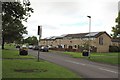
8
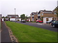
Purbeck Gardens
A suburban scene in Cramlington's Eastfield.
Image: © Weston Beggard
Taken: 20 May 2006
0.24 miles
9
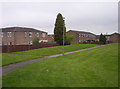
Eastfield Estate
The rear of Broomylinn Place and Byrness Row, from one of the pedestrian-only paths that criss-cross the estate.
Image: © Weston Beggard
Taken: 20 May 2006
0.24 miles