IMAGES TAKEN NEAR TO
Normanby Gardens, CRAMLINGTON, NE23 1AL
Introduction
This page details the photographs taken nearby to Normanby Gardens, NE23 1AL by members of the Geograph project.
The Geograph project started in 2005 with the aim of publishing, organising and preserving representative images for every square kilometre of Great Britain, Ireland and the Isle of Man.

There are currently over 7.5m images from over14,400 individuals and you can help contribute to the project by visiting https://www.geograph.org.uk
Image Map
Images are licensed for reuse under creativecommons.org/licenses/by-sa/2.0
Notes
- Clicking on the map will re-center to the selected point.
- The higher the marker number, the further away the image location is from the centre of the postcode.
Image Listing (19 Images Found)
Images are licensed for reuse under creativecommons.org/licenses/by-sa/2.0
Image
Details
Distance
2
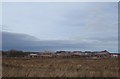
Building site, Cramlington
A former field to the north of Station Road is having houses built upon it. They will be very handy for the railway station.
Image: © Richard Webb
Taken: 26 Jan 2019
0.20 miles
3
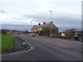
Station Road, Cramlington
The B1326. The houses are on Osbourne Terrace. As it says on the tin, follow this road and you will come to Cramlington Station.
To the south of the road there is a big shopping centre and beyond Osbourne Terrace, a large area of open ground.
Image: © Richard Webb
Taken: 26 Jan 2019
0.21 miles
5
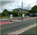
Traffic island, Station Road, Cramlington
Image: © Alex McGregor
Taken: 16 Jun 2011
0.22 miles
6
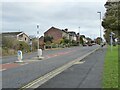
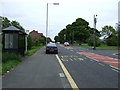
Station Road, Cramlington
From the Sunnyside junction.
Image: © Russel Wills
Taken: 13 Nov 2021
0.22 miles
7
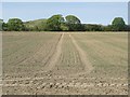
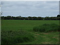
Arable field in Cramlington
An arable field which is more or less surrounded by development. The crop in the field is probably spring barley.
Image: © Graham Robson
Taken: 15 May 2016
0.23 miles
8
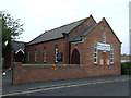
Welcome Methodist Church Cramlington
'Welcome to Welcome Methodist Church! Don't forget to like or follow us so you can find out about our work in Cramlington, join us for services or one of our community groups. Thanks for visiting our church page and we hope to see you soon!' https://www.facebook.com/Welcomemethodistchurchcramlington/
Image: © Russel Wills
Taken: 13 Nov 2021
0.23 miles
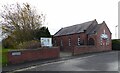
10
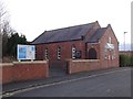
Station Terrace Methodist Church, Cramlington
Cramlington village was strung out between the station and the medieval centre around St Nicholas Church. The chapel was about halfway along the narrow built up area. Today it has a shopping centre for a neighbour. I was too late for the cafe - shame, church cafes are usually pretty good.
Good to see the chapel open; there are many disused churches in the Northumberland coalfields, their congregations or even whole communities lost when the mines closed.
Image: © Richard Webb
Taken: 26 Jan 2019
0.23 miles