IMAGES TAKEN NEAR TO
Longmeadows, BEDLINGTON, NE22 6BR
Introduction
This page details the photographs taken nearby to Longmeadows, NE22 6BR by members of the Geograph project.
The Geograph project started in 2005 with the aim of publishing, organising and preserving representative images for every square kilometre of Great Britain, Ireland and the Isle of Man.

There are currently over 7.5m images from over14,400 individuals and you can help contribute to the project by visiting https://www.geograph.org.uk
Image Map
Images are licensed for reuse under creativecommons.org/licenses/by-sa/2.0
Notes
- Clicking on the map will re-center to the selected point.
- The higher the marker number, the further away the image location is from the centre of the postcode.
Image Listing (7 Images Found)
Images are licensed for reuse under creativecommons.org/licenses/by-sa/2.0
Image
Details
Distance
2
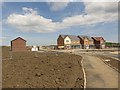
New housing development, Netherton Lane, Bedlington
A new housing development on a greenfield site on the western edge of Bedlington.
Image: © Graham Robson
Taken: 3 Jun 2017
0.15 miles
3
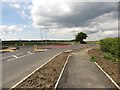
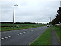
New roundabout on Netherton Lane, Bedlington
A new housing estate is under construction out of the photo on the right. To facilitate access to the new development a roundabout has been built on Netherton Lane where the new access meets an existing road junction.
Image: © Graham Robson
Taken: 3 Jun 2017
0.15 miles
6

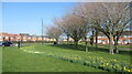
North Ridge, Westlea
A suburb of Bedlington.
Image: © Russel Wills
Taken: 11 May 2015
0.21 miles
7
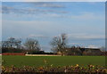
Blue House Farm, near Bedlington
Once surrounded by Coal Pits this farm now has a rather more picturesque setting
Image: © Alan Fearon
Taken: 13 Dec 2005
0.22 miles