IMAGES TAKEN NEAR TO
Arundel Close, BEDLINGTON, NE22 5YJ
Introduction
This page details the photographs taken nearby to Arundel Close, NE22 5YJ by members of the Geograph project.
The Geograph project started in 2005 with the aim of publishing, organising and preserving representative images for every square kilometre of Great Britain, Ireland and the Isle of Man.

There are currently over 7.5m images from over14,400 individuals and you can help contribute to the project by visiting https://www.geograph.org.uk
Image Map
Images are licensed for reuse under creativecommons.org/licenses/by-sa/2.0
Notes
- Clicking on the map will re-center to the selected point.
- The higher the marker number, the further away the image location is from the centre of the postcode.
Image Listing (23 Images Found)
Images are licensed for reuse under creativecommons.org/licenses/by-sa/2.0
Image
Details
Distance
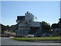
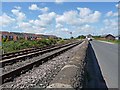
1
Bedlington North
Signal box and level crossing.
Image: © Russel Wills
Taken: 19 Feb 2016
0.09 miles
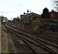
2
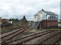
Bedlington North Signal Box
Bedlington North Signal Box shot toward Ashington & Choppington
Image: © Kevin Richardson
Taken: 16 Mar 2008
0.11 miles
3
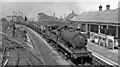
Bedlington Station (remains), with Up coal train
View northward, towards Ashington and Newbiggin (to the right) and Morpeth (to the left). The station had been closed about six months before (2/11/64), together with the Newcastle - Newbiggin passenger service; even the freight traffic of this great South Northumberland area, which was steam-hauled longer than most (late into 1967), was doomed. The locomotive was one of the long-lived and capable NE J27 0-6-0's, No. 65834. See also Image] and Image
Image: © Ben Brooksbank
Taken: 12 May 1965
0.11 miles
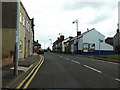
4
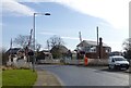
Barrington Road
Barrington Road Bedlington Station heading toward Choppington
Image: © Kevin Richardson
Taken: 16 Mar 2008
0.11 miles
6

Bedlington Station
View northward, towards Ashington and Newbiggin (curving right at North Box), and Morpeth (left at Box); Morpeth branch closed 3/4/50, Ashington and Newbiggin 2/11/64.
Image: © Ben Brooksbank
Taken: 12 May 1965
0.14 miles
7
Station Road
View of Station Road Bedlington Station
Image: © Kevin Richardson
Taken: 16 Mar 2008
0.16 miles
9
Branch Line of the Blyth & Tyne Line
Blyth & Tyne Branch Line looking toward disused Railway Station at Bedlington Station. Much information on this station and the associated railway lines, maps of the area and pictures of the station in use can be found at http://www.disused-stations.org.uk/b/bedlington/index.shtml
Image: © Kevin Richardson
Taken: 16 Mar 2008
0.18 miles
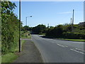
10
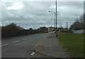
Barrington Road
To the left of the road is a freight-only railway line (part of the old Blyth and Tyne Railway network) which runs through to Morpeth. To the left again is a large modern housing estate.
Image: © Oliver Dixon
Taken: 13 Jul 2011
0.18 miles