IMAGES TAKEN NEAR TO
Bridge Street, BLAYDON-ON-TYNE, NE21 4NR
Introduction
This page details the photographs taken nearby to Bridge Street, NE21 4NR by members of the Geograph project.
The Geograph project started in 2005 with the aim of publishing, organising and preserving representative images for every square kilometre of Great Britain, Ireland and the Isle of Man.

There are currently over 7.5m images from over14,400 individuals and you can help contribute to the project by visiting https://www.geograph.org.uk
Image Map
Images are licensed for reuse under creativecommons.org/licenses/by-sa/2.0
Notes
- Clicking on the map will re-center to the selected point.
- The higher the marker number, the further away the image location is from the centre of the postcode.
Image Listing (54 Images Found)
Images are licensed for reuse under creativecommons.org/licenses/by-sa/2.0
Image
Details
Distance
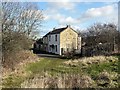
1
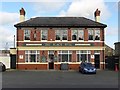
The Black Bull, Bridge Street, Blaydon
Image: © Andrew Curtis
Taken: 24 Feb 2012
0.02 miles
2
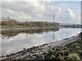
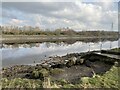
River Tyne downstream of Blaydon Burn
Image: © Anthony Foster
Taken: 25 Feb 2024
0.05 miles
4
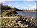
Outlet of Blaydon Burn at River Tyne
The burn runs in a culvert below a track and under the Newcastle to Carlisle railway line which runs here close to the river. A new path is being made on the promenade between the railway and river bank, which will form the new line of Keelman's Way, a cycle path on the south side of the Tyne http://www.cycle-routes.org/cycle-gateshead/routes/keelmans/keel_01rev.html
Image: © Andrew Curtis
Taken: 24 Feb 2012
0.06 miles
5
Outfall of Blaydon Burn into the River Tyne
Image: © Anthony Foster
Taken: 25 Feb 2024
0.06 miles
6
Horse Crofts, Blaydon
The wooded Blaydon Burn is on the left.
Image: © Andrew Curtis
Taken: 24 Feb 2012
0.07 miles
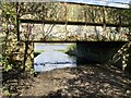
7
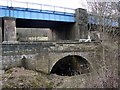
Bridges over the lower Blaydon Burn
The old road bridge in the foreground was built for the Hexham Turnpike Trust in 1778. The large road bridge behind was added in 1936.
http://list.english-heritage.org.uk/resultsingle.aspx?uid=1380569
From this point to its outlet into the River Tyne, the Blaydon Burn flows in a culvert below the track and railway line.
Image: © Andrew Curtis
Taken: 24 Feb 2012
0.08 miles
9
Blaydon Burn from road bridge
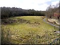
The area of grassland beside Blaydon Burn at its northern end was once part of Cowen's Low Yard, a firebrick manufactory. The factory, opened in 1838, and at peak could make 6 million firebricks a year. The factory closed in 1975 and the walls you can still see near the bridge are part of a kiln back. The line of the Blaydon Burn Waggonway can be seen on the right side. The impoverished grassland created here is rich in wildflowers and supports dingy skipper buterflies.
Image: © Andrew Curtis
Taken: 24 Feb 2012
0.11 miles
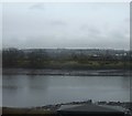
10
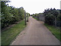
Cycle way
Cycle way next to the River Tyne.
Image: © T simpson
Taken: 26 Aug 2007
0.12 miles