IMAGES TAKEN NEAR TO
BLAYDON-ON-TYNE, NE21 4NB
Introduction
This page details the photographs taken nearby to NE21 4NB by members of the Geograph project.
The Geograph project started in 2005 with the aim of publishing, organising and preserving representative images for every square kilometre of Great Britain, Ireland and the Isle of Man.

There are currently over 7.5m images from over14,400 individuals and you can help contribute to the project by visiting https://www.geograph.org.uk
Image Map
Images are licensed for reuse under creativecommons.org/licenses/by-sa/2.0
Notes
- Clicking on the map will re-center to the selected point.
- The higher the marker number, the further away the image location is from the centre of the postcode.
Image Listing (11 Images Found)
Images are licensed for reuse under creativecommons.org/licenses/by-sa/2.0
Image
Details
Distance
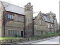
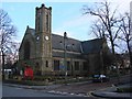
6
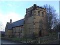
The Castle, Hedgefield
Children’s soft play in the former St Hilda’s church
Image: © Anthony Foster
Taken: 7 Apr 2024
0.12 miles
8
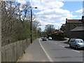
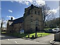
Track, Hedgefield
Track running downhill from Crookhill to the main road at Hedgefield. The tower of St Hilda's Church can be seen below.
Image: © Andrew Curtis
Taken: 24 Feb 2012
0.19 miles
10
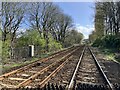
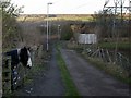
Newcastle and Carlisle Railway at Haugh Lane
Image: © Anthony Foster
Taken: 7 Apr 2024
0.24 miles