IMAGES TAKEN NEAR TO
Valley Crescent, BLAYDON-ON-TYNE, NE21 4HJ
Introduction
This page details the photographs taken nearby to Valley Crescent, NE21 4HJ by members of the Geograph project.
The Geograph project started in 2005 with the aim of publishing, organising and preserving representative images for every square kilometre of Great Britain, Ireland and the Isle of Man.

There are currently over 7.5m images from over14,400 individuals and you can help contribute to the project by visiting https://www.geograph.org.uk
Image Map
Images are licensed for reuse under creativecommons.org/licenses/by-sa/2.0
Notes
- Clicking on the map will re-center to the selected point.
- The higher the marker number, the further away the image location is from the centre of the postcode.
Image Listing (21 Images Found)
Images are licensed for reuse under creativecommons.org/licenses/by-sa/2.0
Image
Details
Distance
1
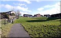
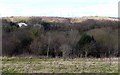
Pathway below Valley Crescent, Winlaton
The path leads down from the housing estate to join old paths which descend the south bank of Blaydon Burn valley.
Image: © Andrew Curtis
Taken: 24 Feb 2012
0.04 miles
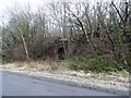
2
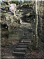
Steps on east side of Blaydon Burn valley
The steps to the north-east of the former coke cutting platform provide access to two converging tracks on the east side of the valley. To its left is a brick structure thought to be associated with former footbridge that crossed the railway lines in the valley bottom at a high level.
Image: © Andrew Curtis
Taken: 19 Feb 2012
0.06 miles
4
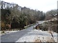
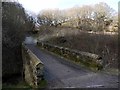
Footpath over Blaydon Burn
The path leads over a stone bridge on its way to Beweshill Lane. Pictured on a frosty winters morning.
Image: © Robert Graham
Taken: 12 Dec 2012
0.07 miles
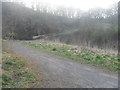
6
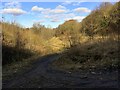
Bridge over Blaydon Burn
The path leads north from the Blaydon Burn Waggonway to Beweshill Lane. The mature stand of oak trees behind are said to support rare purple hairstreak butterflies and the green woodpecker.
Image: © Andrew Curtis
Taken: 19 Feb 2012
0.09 miles
7
Bridge over Blaydon Burn
The path and bridge are part of Blaydon Burn Trail
Image: © Anthony Foster
Taken: 24 Mar 2012
0.09 miles
8
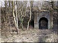
Former entrance to Edward Pit and Tar Tunnel
The disused entrance to an earlier coal mine was reused around 1900 by Priestman Collieries as the entrance to the tar tunnel. This was a transportation tunnel connecting the tar works at Ottovale, on the east side of the valley, with the railway to the Tyne below. When the Ottovale works closed in the late 1950s the tunnel was disused and the entrance bricked up.
Image: © Andrew Curtis
Taken: 19 Feb 2012
0.09 miles
9

Between Francis Street & Helen Street, Winlaton
Image: © Andrew Curtis
Taken: 24 Feb 2012
0.12 miles
10
Entrance to the Edward Pit
This brick arch marks the former entrance to a nineteenth century drift mine in Blaydon Burn.
Image: © Robert Graham
Taken: 12 Dec 2012
0.13 miles