IMAGES TAKEN NEAR TO
Klondyke Walk, BLAYDON-ON-TYNE, NE21 4FG
Introduction
This page details the photographs taken nearby to Klondyke Walk, NE21 4FG by members of the Geograph project.
The Geograph project started in 2005 with the aim of publishing, organising and preserving representative images for every square kilometre of Great Britain, Ireland and the Isle of Man.

There are currently over 7.5m images from over14,400 individuals and you can help contribute to the project by visiting https://www.geograph.org.uk
Image Map
Images are licensed for reuse under creativecommons.org/licenses/by-sa/2.0
Notes
- Clicking on the map will re-center to the selected point.
- The higher the marker number, the further away the image location is from the centre of the postcode.
Image Listing (26 Images Found)
Images are licensed for reuse under creativecommons.org/licenses/by-sa/2.0
Image
Details
Distance
1
New houses overlooking river at South Stella
Image: © Andrew Curtis
Taken: 1 Jan 2015
0.06 miles
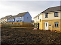
2
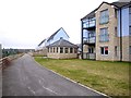
Stella South housing development, Blaydon
Image: © Andrew Curtis
Taken: 22 Feb 2013
0.06 miles
3
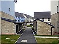
Riverside path on the South Stella estate
A pleasant level path has been constructed along the riverside by the new South Stella housing estate. It continues through to Blaydon station and points east. But the Keelman's Way (National Cycle Network route 141) is still signed via a much less satisfactory route alongside Stella Road (see Image).
Image: © Oliver Dixon
Taken: 29 May 2018
0.09 miles
4
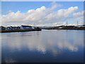
River Tyne and New Housing Development at Ryton Haugh
Image: © Les Hull
Taken: 26 Oct 2011
0.10 miles
5
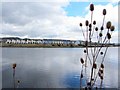
Cromwell Ford Way, South Stella, Blaydon
A sharp bend in the River Tyne at this location (left of the path) is known by the name 'Cromwell' Image
In 1128, the name was 'Crumbwell'. 'Crumbe' is Old English for a bend (in a river), 'Crumb' means 'crooked', 'wella' means 'spring' and 'wel' means 'deep pool'. Thus 'spring in or by the river bend' or 'crooked winding stream'. At one time it was owned by the bishop of Durham and was an important location for fishing. The main catch would have been salmon, but eels, pike, minnow, burbot, trout and lamprey would also have been taken.
http://www.twsitelines.info/SMR/1695
There was, however, a ford here at one time, and also a connection with Oliver Cromwell http://en.wikipedia.org/wiki/Oliver_cromwell
The Protector's army camped on Ryton Haugh while he himself quartered at Stella House, before crossing the river at this point, on the march to Dunbar in 1650.
Image: © Andrew Curtis
Taken: 22 Feb 2013
0.11 miles
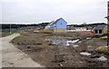
6

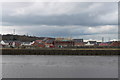
Construction site, South Stella, Blaydon
Image: © Andrew Curtis
Taken: 22 Feb 2013
0.11 miles
7
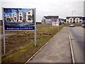
Stella South housing development off King Oswald Drive, Blaydon
Image: © Andrew Curtis
Taken: 22 Feb 2013
0.11 miles
8
Cromwell Ford Way, South Stella, Blaydon
See photo here Image
Image: © Andrew Curtis
Taken: 4 Apr 2013
0.11 miles
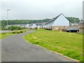
10
King Oswald Drive, Stella South, Blaydon
Part of the Stella Riverside housing development on the former site of Stella South Power Station Image
Blaydon Race Course, scene of the Geordie anthem, 'The Blaydon Races', written in the 19th century by Geordie Ridley, was located in this area of Stella Haugh 1 mile (1.6 km) west of Blaydon. Stella South Power Station was built on the site of the by then disused race track in the early 1950s.
http://www.guardian.co.uk/uk/the-northerner/2012/jan/12/newcastle
Image: © Andrew Curtis
Taken: 22 Feb 2013
0.12 miles