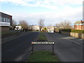
IMAGES TAKEN NEAR TO
Chesmond Drive, BLAYDON-ON-TYNE, NE21 4BL
Introduction
This page details the photographs taken nearby to Chesmond Drive, NE21 4BL by members of the Geograph project.
The Geograph project started in 2005 with the aim of publishing, organising and preserving representative images for every square kilometre of Great Britain, Ireland and the Isle of Man.

There are currently over 7.5m images from over14,400 individuals and you can help contribute to the project by visiting https://www.geograph.org.uk
Image Map
Images are licensed for reuse under creativecommons.org/licenses/by-sa/2.0
Notes
- Clicking on the map will re-center to the selected point.
- The higher the marker number, the further away the image location is from the centre of the postcode.
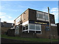
Image Listing (15 Images Found)
Images are licensed for reuse under creativecommons.org/licenses/by-sa/2.0
Image
Details
Distance
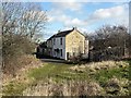
3
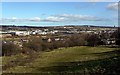
Field west of Blaydon
Taken from the path on the bank above Horse Crofts and Cochran Street just below the playing field. The path descends to the west end of Delacours Road. View of the River Tyne east of Newburn Riverside industrial estate near Lemington.
Image: © Andrew Curtis
Taken: 24 Feb 2012
0.13 miles
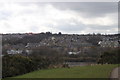
5
Horse Crofts, Blaydon
The wooded Blaydon Burn is on the left.
Image: © Andrew Curtis
Taken: 24 Feb 2012
0.22 miles
6
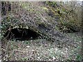
Remains of vaulted ovens near Massey's Forge
The kilns are built of fire-bricks bricks marked ‘E & M', the Emerson and Milner trademark, also made after 1850 by William Cochrane Carr. It is not known whether they are the two Newcastle kilns known to be at Milner's Yard, used for burning gas retorts in 1863, and at that time, part of Cowen's business; or earlier coke ovens, of the rare ‘long oven’ type, which may have been associated with Massey’s Forge steel works.
Image: © Andrew Curtis
Taken: 24 Feb 2012
0.22 miles
7

Blaydon Burn
The east bank of Blaydon Burn, downstream from the site Massey’s Forge, is reinforced by a high stone retaining wall, strengthened at a later time by concrete buttresses. The large sandstone blocks extending from the right are thought to have been part of a former weir or sluice. Old maps show a mill race downstream for one of the burn's C18th watermills, known as Rennison’s or Pickering’s Mill, all remains of which disappeared under Cowen's Low Yard around 1830.
Image: © Andrew Curtis
Taken: 24 Feb 2012
0.23 miles
8
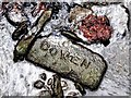
Cowen firebrick and iron slag, Blaydon Burn
Two items illustrating the industrial past of the valley lying in the shallow water of the burn close to the site shown in Image
Cowen's bricks were made from fireclay which is an alumino-silicate mineral found below the coal measures of the Carboniferous Millstone-grit series. Several of the coal mines in the valley produced large quantities of fireclay and the high percentages of silica and low level of impurities, made the bricks particularly suitable for iron, glass and lead making. In 1896 about 6 million firebricks were being made at Blaydon Burn every year, particularly for foreign and colonial exports http://www.flickr.com/photos/michaelbarrow/3640515414/ https://web.archive.org/web/20210515205932/https://www.flickr.com/photos/michaelbarrow/3640515414/
The simple 'COWEN' stamp was used prior to 1926. Other Cowen bricks made later than this are shown here Image and Image
Other makes of firebricks can also be found in and around the burn and associated with former buildings. Those marked 'Lily' were made at a later date at a yard in High Spen.
Local coal was used for steel production which may have been the source of the slag. One particular site in the valley was just upstream from here, at Massey's Forge Image
Fragments of black-lead crucibles, associated with an early form of steel making, were found in the excavation of Massey’s Forge in 1982.
The Cowen Brick - probably the best brick in the world http://www.rolyveitch.20m.com/CowenBrick.html https://web.archive.org/web/20210515205636/http://www.rolyveitch.20m.com/CowenBrick.html
Image: © Andrew Curtis
Taken: 24 Feb 2012
0.23 miles
9
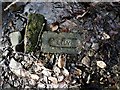
'Lily' bricks, Blaydon Burn
'Lily' bricks were made at the brickworks associated with the Lilley Drift coal mine at Rowlands Gill, opened by Joseph Cowen in 1877. Coal was mined from the Brockwell seam which had good coking qualities. It closed in 1957. Large quantities of fireclay were also extracted and the brickworks remained open until 1977.
Image: © Andrew Curtis
Taken: 24 Feb 2012
0.23 miles
10
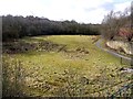
Blaydon Burn from road bridge
The area of grassland beside Blaydon Burn at its northern end was once part of Cowen's Low Yard, a firebrick manufactory. The factory, opened in 1838, and at peak could make 6 million firebricks a year. The factory closed in 1975 and the walls you can still see near the bridge are part of a kiln back. The line of the Blaydon Burn Waggonway can be seen on the right side. The impoverished grassland created here is rich in wildflowers and supports dingy skipper buterflies.
Image: © Andrew Curtis
Taken: 24 Feb 2012
0.23 miles