IMAGES TAKEN NEAR TO
Prestwick, NEWCASTLE UPON TYNE, NE20 9UB
Introduction
This page details the photographs taken nearby to NE20 9UB by members of the Geograph project.
The Geograph project started in 2005 with the aim of publishing, organising and preserving representative images for every square kilometre of Great Britain, Ireland and the Isle of Man.

There are currently over 7.5m images from over14,400 individuals and you can help contribute to the project by visiting https://www.geograph.org.uk
Image Map
Images are licensed for reuse under creativecommons.org/licenses/by-sa/2.0
Notes
- Clicking on the map will re-center to the selected point.
- The higher the marker number, the further away the image location is from the centre of the postcode.
Image Listing (31 Images Found)
Images are licensed for reuse under creativecommons.org/licenses/by-sa/2.0
Image
Details
Distance
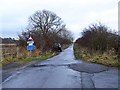
1
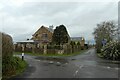
Mayfair House
Looking across the crossroads towards Mayfair House. National Cycle Network route 10 runs left-right.
Image: © DS Pugh
Taken: 19 Dec 2022
0.01 miles
2
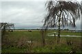
Prestwick Carr
View South with Mayfair House on the right
Image: © Christine Westerback
Taken: 10 Mar 2012
0.01 miles
3
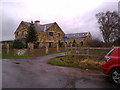
Mayfair House
This new property stands at the crossroads at the West end of Prestwick Carrs. The track going up past the house leads towards the rifle ranges.
Image: © Robert Graham
Taken: 23 Nov 2011
0.01 miles
4
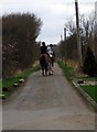
Horse Riders
There are many horses around this area with stables on nearby land
Image: © Christine Westerback
Taken: 10 Mar 2012
0.03 miles
5
Reivers Cycle Route on Prestwick Carr
East of Ponteland and north of Newcastle Airport is an extensive area of low-lying marshy land (Prestwick Carr). The road crossing it is part of National Cycle Network route 10 (Reiver's Route); despite it being tarmac, it is not recommended for motors as coal mining subsidence has resulted in a very fragmented surface.
Image: © Oliver Dixon
Taken: 28 Nov 2013
0.05 miles
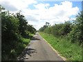
6
The not so bad bit Prestwick Carr Road
A little bit of Somerset in Northumberland, west of the road up from Prestwick things improve, but you would not want to take a car east of the junction.
Image: © Richard Webb
Taken: 1 Oct 2015
0.06 miles
7
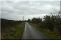
National Cycle Network route 10
Looking along part of NCN route 10 between Ponteland and Dinnington.
Image: © DS Pugh
Taken: 19 Dec 2022
0.06 miles
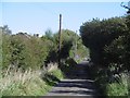
8
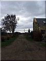
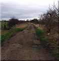
Lane to Prestwick Mill Farm
Looking along the straight lane leading to Prestwick Mill Farm.
Image: © Graham Robson
Taken: 6 Aug 2016
0.06 miles
9
Fields near Mayfair House
Looking across a field of horses near the crossroads.
Image: © DS Pugh
Taken: 19 Dec 2022
0.06 miles
10
Footpath through The Carr
Footpath heading north through Prestwick Carr - a small burn runs parallel to the right.
Image: © Christine Westerback
Taken: 10 Mar 2012
0.09 miles