IMAGES TAKEN NEAR TO
Main Street, NEWCASTLE UPON TYNE, NE20 9NN
Introduction
This page details the photographs taken nearby to Main Street, NE20 9NN by members of the Geograph project.
The Geograph project started in 2005 with the aim of publishing, organising and preserving representative images for every square kilometre of Great Britain, Ireland and the Isle of Man.

There are currently over 7.5m images from over14,400 individuals and you can help contribute to the project by visiting https://www.geograph.org.uk
Image Map
Images are licensed for reuse under creativecommons.org/licenses/by-sa/2.0
Notes
- Clicking on the map will re-center to the selected point.
- The higher the marker number, the further away the image location is from the centre of the postcode.
Image Listing (119 Images Found)
Images are licensed for reuse under creativecommons.org/licenses/by-sa/2.0
Image
Details
Distance
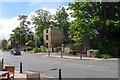
1
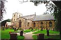
Ponteland, Northumberland, The Church of St Mary The Virgin
Image: © Bill Henderson
Taken: Unknown
0.02 miles
3
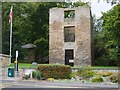
Vicar's Pele Tower, Ponteland
The Vicarage Tower or Vicar's Pele was built around 1400. Pele Towers were defensive buildings constructed to provide defence during the border raids. It was formerly the residence of the vicars of Ponteland and in the C18th was incorporated into a much larger vicarage complex. This was demolished in 1860 although the tower was left as a harness room. The tower was restored in 1971 and 2002.
Image: © Andrew Curtis
Taken: 24 Sep 2010
0.04 miles
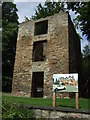
5
Vicar's Pele Tower House, Ponteland
From English Heritage's listing details:
'The monument includes a tower house of medieval date situated in the centre of Ponteland. The tower, built of random rubble and patched with brick, is roofless and survives as a standing building three storeys high. Some restoration work was carried out in 1971. It is rectangular in plan and measures a maximum 7m north-south by 6.2m east-west. The south elevation contains three large openings, one on each floor, with concrete lintels and sills and metal grilles incorporated during the work in 1971; the ground floor opening is a doorway and clearly a later insertion. The west elevation has several blocked openings, including two window loops and two doorways, as well as the chamfered jamb of a doorway, a series of socket holes outlining the roof line of a former attached building and a round window, possibly of 18th century date. The north elevation also contains two blocked doorways, the lower one probably a later insertion and the first floor one possibly contemporary with a mural stair of which there are indications in the wall fabric. The first floor doorway incorporates part of a medieval incised grave cover in its western jamb. Other openings include two window loops at first and second floor level, where there is also another old roof line. The east elevation contains a blocked window loop at first floor level with a larger bricked-up opening to the south; at second floor level there is another circular window similar to that on the west elevation. Internally, there are traces of a former north-south vault, which has now been cut away, and various blocked openings. In the north east corner, at first floor level, a small room is interpreted as a garderobe. The tower, which is a Grade II Listed Building, is commonly called the Vicar's Pele and was part of the former vicarage which was demolished at the end of the 19th century, leaving the tower standing alone. The earliest documentary reference to the tower is in a list of 1415. It has been suggested that the tower was created in the 15th century by the conversion of a 13th century hall house. There are slight earthworks on the north and west sides but no clear indications of the extent of this former building. The metal window grilles, first floor fireplace and external wall plaque are excluded from the scheduling, although the structure to which these features are attached is included.'
Image: © Anthony Foster
Taken: 29 May 2015
0.04 miles
6
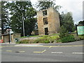
Tower House ruin. A Vicar's Pele
Said to be 14th Century, but the existing remains are all 16th Century
(Pevsner)
Image: © Martin Dawes
Taken: 7 Sep 2019
0.04 miles
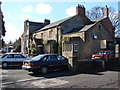
7
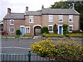
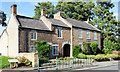
Former farmhouse and cottage, Main Street, Ponteland
The farmhouse and cottage were built in the C18th and early C19th http://www.keystothepast.info/article/10339/Site-Details?PRN=N11013
Image: © Andrew Curtis
Taken: 24 Sep 2010
0.05 miles
8
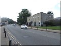
Barclays Bank, Ponteland
Looking across Main Street towards the building housing the local branch of Barclays Bank in the prosperous small town of Ponteland.
Image: © Graham Robson
Taken: 6 Aug 2016
0.05 miles
9
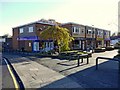
Ponteland Shopping Centre, Thornhill Road
Merton Way is to the right Image
Image: © Andrew Curtis
Taken: 6 Nov 2010
0.05 miles
10
Two houses on the north side of Main Street
The houses are in Ponteland and face the Waitrose store there.
The centre section is unusual being presumably an addition to the left hand property - the brickwork is different. Also in that addition the upper floor window is raised, probably a necessity to accommodate the arch of the passage through to the rear.
Image: © Trevor Littlewood
Taken: 23 Aug 2019
0.05 miles