IMAGES TAKEN NEAR TO
Callerton Lane, NEWCASTLE UPON TYNE, NE20 9EG
Introduction
This page details the photographs taken nearby to Callerton Lane, NE20 9EG by members of the Geograph project.
The Geograph project started in 2005 with the aim of publishing, organising and preserving representative images for every square kilometre of Great Britain, Ireland and the Isle of Man.

There are currently over 7.5m images from over14,400 individuals and you can help contribute to the project by visiting https://www.geograph.org.uk
Image Map
Images are licensed for reuse under creativecommons.org/licenses/by-sa/2.0
Notes
- Clicking on the map will re-center to the selected point.
- The higher the marker number, the further away the image location is from the centre of the postcode.
Image Listing (94 Images Found)
Images are licensed for reuse under creativecommons.org/licenses/by-sa/2.0
Image
Details
Distance
1
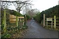
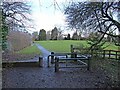
Callerton Lane entrance
Looking into Ponteland Park from Callerton Lane along the course of the former railway line.
Image: © DS Pugh
Taken: 19 Dec 2022
0.02 miles
2
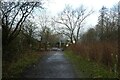
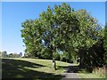
Approaching Callerton Lane
Connecting the airport and Ponteland along the old railway. The path was very slippery with the ice from several cold days now melting on this mild day.
Image: © DS Pugh
Taken: 19 Dec 2022
0.04 miles
3
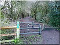
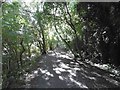
Reivers Cycle Route, Ponteland
Regional Route 10 of the National Cycle Network here follows the line of an old railway which ran from Darras Hall via Ponteland to South Gosforth. The railway came very late in the railway era to Darras Hall. It only opened in 1913, was never a commercial success and closed to passengers in 1929. The line finally closed in 1954. More information on Ponteland Station and the line can be found at http://www.disused-stations.org.uk/p/ponteland/index.shtml
The barriers hopefully keep out motor bikes. Horses can step over the horse stile to the right.
Image: © Oliver Dixon
Taken: 14 Feb 2011
0.04 miles
5
Motor bike barrier, Ponteland
The green is the site where once the railway from Darras Hall came in to join the line from South Gosforth to Ponteland. Towards the camera, Regional Route 10 (Reivers Route) of the National Cycle Network follows the line to Darras Hall station and beyond to Belsay Colliery. The barrier hopefully keeps out motor bikes, horses can step over the horse stile to the left.
Image: © Oliver Dixon
Taken: 14 Feb 2011
0.07 miles
7
Railway trackbed, Ponteland
This was a commuter railway from Darras Hall until closure to passengers in 1929 and the later life as a mineral railway ended in 1954. It is now a well shaded path through an upscale housing area.
Image: © Richard Webb
Taken: 1 Oct 2015
0.09 miles
9
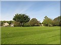
Grass area off Callerton Lane
A small area of undeveloped grassland beside Callerton Lane. A tree has been planted in the centre of the area to mark the millennium.
Image: © Graham Robson
Taken: 23 Sep 2017
0.09 miles
10
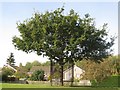
Millennium Tree, Ponteland
A maturing tree planted to mark the passing of the year 2000 protected by metal railings.
Image: © Graham Robson
Taken: 23 Sep 2017
0.09 miles