IMAGES TAKEN NEAR TO
Street Houses, NEWCASTLE UPON TYNE, NE20 9BT
Introduction
This page details the photographs taken nearby to Street Houses, NE20 9BT by members of the Geograph project.
The Geograph project started in 2005 with the aim of publishing, organising and preserving representative images for every square kilometre of Great Britain, Ireland and the Isle of Man.

There are currently over 7.5m images from over14,400 individuals and you can help contribute to the project by visiting https://www.geograph.org.uk
Image Map
Images are licensed for reuse under creativecommons.org/licenses/by-sa/2.0
Notes
- Clicking on the map will re-center to the selected point.
- The higher the marker number, the further away the image location is from the centre of the postcode.
Image Listing (22 Images Found)
Images are licensed for reuse under creativecommons.org/licenses/by-sa/2.0
Image
Details
Distance
2
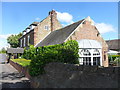
The Badger Inn, Street Houses
Formerly Street House Farmhouse, built in the late 18th century. It is listed Grade II.
Image: © Anthony Foster
Taken: 30 May 2015
0.05 miles
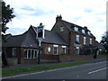
3

The Badger, Street Houses, Ponteland
Street Houses was described in the Northumberland OS Name Book for Ponteland (c1860) as "a small hamlet consisting of a gentleman’s house, a farm house and a few cottages".
http://namebooks.org.uk/browse/main/?OSref=407&Page=89
According to a booklet by Ponteland Civic Society (August 2018) about the 26 framed old postcards shown around the interior of the inn:
"Built in the late 18th century, The Badger has served a number of purposes before welcoming the locals of the hamlet of Street Houses. Originally a gentleman's residence the pub was later split into three houses, which were occupied through the years by a succession of farmers, yeomen and a cattle dealer, before eventually becoming The Badger. The themed interior was provided with a large number of framed pictures, and no less than 26 of these comprised historic photographs of Ponteland. Most were derived from postcards; this booklet lists them and provides some background to the scenes illustrated".
http://www.pontcivicsociety.pontelandonline.co.uk/Archive/BADGER_A4_SHEET_VERSION.pdf https://web.archive.org/web/20201203064014/http://pontcivicsociety.pontelandonline.co.uk/Archive/BADGER_A4_SHEET_VERSION.pdf
Image: © Andrew Curtis
Taken: 21 Dec 2021
0.05 miles
6
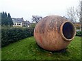
Giant ceramic jar at entrance to Dobbies Garden Centre
Behind is the side car-park entrance to The Badger Inn and Restaurant Image
Image: © Andrew Curtis
Taken: 21 Dec 2021
0.08 miles
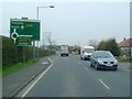
8
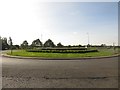
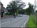
Roundabout at Street Houses
A large roundabout at the junction of the A696 and B6545 roads to the east of Ponteland.
Image: © Graham Robson
Taken: 23 Sep 2017
0.14 miles
9
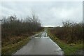
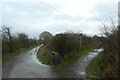
Track beside the railway path
Looking along a track from the course of the former railway line near Ponteland.
Image: © DS Pugh
Taken: 19 Dec 2022
0.15 miles
10
Railway path and track
The former railway line to Ponteland is on the right.
Image: © DS Pugh
Taken: 19 Dec 2022
0.15 miles