The Badger, Street Houses, Ponteland
Introduction
The photograph on this page of The Badger, Street Houses, Ponteland by Andrew Curtis as part of the Geograph project.
The Geograph project started in 2005 with the aim of publishing, organising and preserving representative images for every square kilometre of Great Britain, Ireland and the Isle of Man.

There are currently over 7.5m images from over 14,400 individuals and you can help contribute to the project by visiting https://www.geograph.org.uk
The Badger, Street Houses, Ponteland
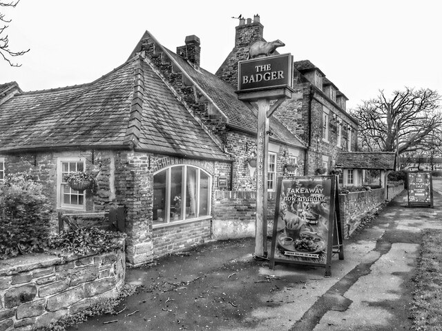
Image: © Andrew Curtis Taken: 21 Dec 2021
Street Houses was described in the Northumberland OS Name Book for Ponteland (c1860) as "a small hamlet consisting of a gentleman’s house, a farm house and a few cottages". http://namebooks.org.uk/browse/main/?OSref=407&Page=89 According to a booklet by Ponteland Civic Society (August 2018) about the 26 framed old postcards shown around the interior of the inn: "Built in the late 18th century, The Badger has served a number of purposes before welcoming the locals of the hamlet of Street Houses. Originally a gentleman's residence the pub was later split into three houses, which were occupied through the years by a succession of farmers, yeomen and a cattle dealer, before eventually becoming The Badger. The themed interior was provided with a large number of framed pictures, and no less than 26 of these comprised historic photographs of Ponteland. Most were derived from postcards; this booklet lists them and provides some background to the scenes illustrated". http://www.pontcivicsociety.pontelandonline.co.uk/Archive/BADGER_A4_SHEET_VERSION.pdf https://web.archive.org/web/20201203064014/http://pontcivicsociety.pontelandonline.co.uk/Archive/BADGER_A4_SHEET_VERSION.pdf
Images are licensed for reuse under creativecommons.org/licenses/by-sa/2.0
Image Location
Latitude
55.041835
Longitude
-1.723304