IMAGES TAKEN NEAR TO
Western Way, NEWCASTLE UPON TYNE, NE20 9AW
Introduction
This page details the photographs taken nearby to Western Way, NE20 9AW by members of the Geograph project.
The Geograph project started in 2005 with the aim of publishing, organising and preserving representative images for every square kilometre of Great Britain, Ireland and the Isle of Man.

There are currently over 7.5m images from over14,400 individuals and you can help contribute to the project by visiting https://www.geograph.org.uk
Image Map
Images are licensed for reuse under creativecommons.org/licenses/by-sa/2.0
Notes
- Clicking on the map will re-center to the selected point.
- The higher the marker number, the further away the image location is from the centre of the postcode.
Image Listing (14 Images Found)
Images are licensed for reuse under creativecommons.org/licenses/by-sa/2.0
Image
Details
Distance
1
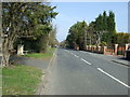
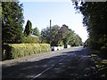
Western Way, Darras Hall
Mature gardens in an early 1900s residential area.
Image: © Richard Webb
Taken: 1 Oct 2015
0.04 miles
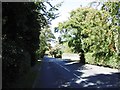
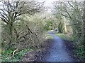
2
Track leading to Darras Hall and Ponteland
Image: © Les Hull
Taken: 14 Apr 2021
0.07 miles
3
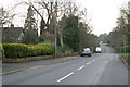
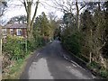
Western Way, Darras Hall, Ponteland
Looking south.
Image: © Phil Thirkell
Taken: 13 Jan 2006
0.07 miles
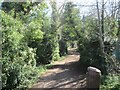
5
Reivers Cycle Route at Darras Hall
Regional Route 10 of the National Cycle Network here follows the line of an old railway from Darras Hall out to Belsay Colliery (status bridleway).
Image: © Oliver Dixon
Taken: 14 Feb 2011
0.09 miles
6
The Crescent, Darras Hall
The cycle track and bridleway entry to Darras Hall estate.
Image: © Andrew Curtis
Taken: 27 Feb 2009
0.10 miles
7
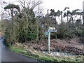
Signpost at the edge of Darras Hall
Signs indicating the Reivers Cycle Route, Regional Route 10 of the National Cycle Network have been affixed to this signpost. Woe betide any cyclist who attempts to navigate the route west of here - one of the worst in the entire National Network. The first house in the up-market estate of Darras Hall can be seen through the trees.
Image: © Oliver Dixon
Taken: 14 Feb 2011
0.10 miles
8
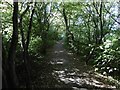
Wallridge Mineral Railway
Long closed railway, now a path through Darras Hall.
Image: © Richard Webb
Taken: 1 Oct 2015
0.13 miles
9
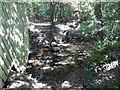
Burn on the edge of Darras Hall
Beyond the stepping stones (behind the camera) is open country. The woodland is a narrow strip in suburbia.
Image: © Richard Webb
Taken: 1 Oct 2015
0.14 miles