IMAGES TAKEN NEAR TO
Ryal, NEWCASTLE UPON TYNE, NE20 0SB
Introduction
This page details the photographs taken nearby to NE20 0SB by members of the Geograph project.
The Geograph project started in 2005 with the aim of publishing, organising and preserving representative images for every square kilometre of Great Britain, Ireland and the Isle of Man.

There are currently over 7.5m images from over14,400 individuals and you can help contribute to the project by visiting https://www.geograph.org.uk
Image Map
Images are licensed for reuse under creativecommons.org/licenses/by-sa/2.0
Notes
- Clicking on the map will re-center to the selected point.
- The higher the marker number, the further away the image location is from the centre of the postcode.
Image Listing (15 Images Found)
Images are licensed for reuse under creativecommons.org/licenses/by-sa/2.0
Image
Details
Distance
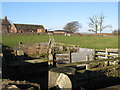
1
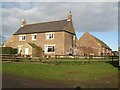
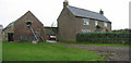
The farmhouse and barn at West Side
Unusually for this area, the buildings are of brick, rather than local stone.
Image: © Mike Quinn
Taken: 29 Nov 2007
0.01 miles


10
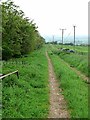
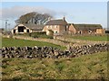
Byway at West Side Farm
This public byway is followed by an off-road alternative for the Reivers Cycle Route (National Cycle Network Regional Route 10).
Image: © Oliver Dixon
Taken: 29 May 2012
0.09 miles