IMAGES TAKEN NEAR TO
Belsay, NEWCASTLE UPON TYNE, NE20 0HQ
Introduction
This page details the photographs taken nearby to NE20 0HQ by members of the Geograph project.
The Geograph project started in 2005 with the aim of publishing, organising and preserving representative images for every square kilometre of Great Britain, Ireland and the Isle of Man.

There are currently over 7.5m images from over14,400 individuals and you can help contribute to the project by visiting https://www.geograph.org.uk
Image Map
Images are licensed for reuse under creativecommons.org/licenses/by-sa/2.0
Notes
- Clicking on the map will re-center to the selected point.
- The higher the marker number, the further away the image location is from the centre of the postcode.
Image Listing (5 Images Found)
Images are licensed for reuse under creativecommons.org/licenses/by-sa/2.0
Image
Details
Distance
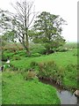
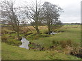
2
How Burn
Meandering through the pasture.
Image: © Russel Wills
Taken: 30 Jun 2016
0.21 miles
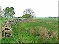
3
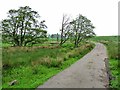
Byway to Sandyford
Unusually, this byway open to all traffic from the A696 through to Sandyford has a tarmac surface throughout. The bridge crosses the How Burn in the middle of some marshy land.
Image: © Oliver Dixon
Taken: 29 May 2012
0.21 miles