IMAGES TAKEN NEAR TO
Belsay, NEWCASTLE UPON TYNE, NE20 0EZ
Introduction
This page details the photographs taken nearby to NE20 0EZ by members of the Geograph project.
The Geograph project started in 2005 with the aim of publishing, organising and preserving representative images for every square kilometre of Great Britain, Ireland and the Isle of Man.

There are currently over 7.5m images from over14,400 individuals and you can help contribute to the project by visiting https://www.geograph.org.uk
Image Map
Images are licensed for reuse under creativecommons.org/licenses/by-sa/2.0
Notes
- Clicking on the map will re-center to the selected point.
- The higher the marker number, the further away the image location is from the centre of the postcode.
Image Listing (8 Images Found)
Images are licensed for reuse under creativecommons.org/licenses/by-sa/2.0
Image
Details
Distance
1
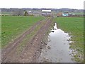
Saugh House
Farm on the A696 trunk road from Newcastle to Jedburgh (the road itself cannot be seen but lies this side of the farm). The track in the foreground is a bridleway cutting the corner between the B6309 and the A696.
Image: © Oliver Dixon
Taken: 8 Apr 2010
0.04 miles
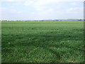
2
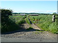
Track off the B6309 to Saugh House
Image: © Alexander P Kapp
Taken: 19 Jun 2012
0.10 miles
3
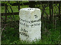
How far to go?
Milestone at the junction of the B6309 and the A696. The B6309 is a real "drivers" road to Stamfordham although often pathetically wasted on weekend tourists.
Image: © No Body
Taken: 22 Apr 2006
0.18 miles
4
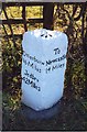
Old Milestone by the A696, near Saugh House, Belsay
Carved stone post by the A696, in parish of BELSAY (CASTLE MORPETH District), East of Saugh House at junction with B6309, in hedge on grass verge, on South side of road. New Ponteland stone, erected by the Ponteland turnpike trust in the 19th century.
Inscription reads:-
: (To) / Otterburn / 16 Miles / Jedbro / 42 Miles : : To / Newcastle / 14 Miles :
Carved benchmark and rivet on top; obliterated carved benchmark on left side.
Grade II Listed. List Entry Number: 1042833
https://historicengland.org.uk/listing/the-list/list-entry/1042833
Milestone Society National ID: NB_NCJB14.
Image: © IA Davison
Taken: 26 Aug 2002
0.19 miles
5
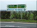
Road signs at the B6309, A696 junction
Just in case you do not spot the milestone at this junction there are modern roadsigns on the other side of the road.
Image: © No Body
Taken: 22 Apr 2006
0.19 miles
7
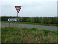
To Bolam we will go
The junction of the minor road to Bolam off the A696. This junction is only very short distance from the junction of the B6309 with the A696 and on most maps it looks like a crossroads but there is a small offset. The boundary between NZ0879 and NZ0979 runs between the two junctions.
Image: © No Body
Taken: 22 Apr 2006
0.24 miles
8
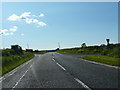
Junction of the B6309 and the A696 with a minor road to the right
Image: © Alexander P Kapp
Taken: 19 Jun 2012
0.24 miles