IMAGES TAKEN NEAR TO
Elsdon, NEWCASTLE UPON TYNE, NE19 1BD
Introduction
This page details the photographs taken nearby to NE19 1BD by members of the Geograph project.
The Geograph project started in 2005 with the aim of publishing, organising and preserving representative images for every square kilometre of Great Britain, Ireland and the Isle of Man.

There are currently over 7.5m images from over14,400 individuals and you can help contribute to the project by visiting https://www.geograph.org.uk
Image Map
Images are licensed for reuse under creativecommons.org/licenses/by-sa/2.0
Notes
- Clicking on the map will re-center to the selected point.
- The higher the marker number, the further away the image location is from the centre of the postcode.
Image Listing (9 Images Found)
Images are licensed for reuse under creativecommons.org/licenses/by-sa/2.0
Image
Details
Distance
2
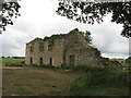
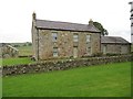
The Haining
A derelict farmstead near Elsdon. For more information, see Keys to the Past: http://www.keystothepast.info/article/10339/Site-Details?PRN=N9772
Image: © Pete Saunders
Taken: 24 Jul 2009
0.01 miles
5
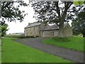
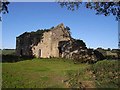
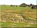
The Haining (Elsdon)
A photo http://www.keystothepast.info/article/10339/Site-Details?PRN=N9772 taken in the 1960s shows that the building still had a roof then, but photos on Geograph taken in 2009 http://www.geograph.org.uk/gridref/NY9292?takenyear=2009 show it as a total ruin. What a transformation - I assume a holiday let?
"The derelict remains of a small 17th-century farmstead called The Haining stand west of Elsdon village. The earliest documentary record of the farm is in 1663 and it also appears in later 17th-century parish registers. The farmhouse was probably built in about 1650 and is a typical Northumbrian pattern, being only one rook deep. It has a central door leading into a lobby with a room each side, a flight of stair lead to the first floor which is a single large room." http://www.keystothepast.info/article/10339/Site-Details?PRN=N9772
Image: © Les Hull
Taken: 14 Aug 2019
0.02 miles
8
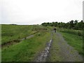
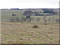
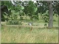
Footbridge over Elsdon Burn
Tuley tubes mark an extensive area of tree planting to the south-west of Elsdon village.
Image: © Oliver Dixon
Taken: 4 Oct 2009
0.15 miles