IMAGES TAKEN NEAR TO
Stamfordham, NEWCASTLE UPON TYNE, NE18 0LG
Introduction
This page details the photographs taken nearby to NE18 0LG by members of the Geograph project.
The Geograph project started in 2005 with the aim of publishing, organising and preserving representative images for every square kilometre of Great Britain, Ireland and the Isle of Man.

There are currently over 7.5m images from over14,400 individuals and you can help contribute to the project by visiting https://www.geograph.org.uk
Image Map
Images are licensed for reuse under creativecommons.org/licenses/by-sa/2.0
Notes
- Clicking on the map will re-center to the selected point.
- The higher the marker number, the further away the image location is from the centre of the postcode.
Image Listing (11 Images Found)
Images are licensed for reuse under creativecommons.org/licenses/by-sa/2.0
Image
Details
Distance
1
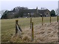
Nesbitt Hill Head
Farm on the west edge of the military site of Albemarle Barracks, formerly RAF Ouston.
Image: © Andrew Curtis
Taken: 10 Feb 2012
0.01 miles
2
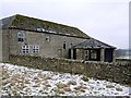
Derelict gin-gang at rear of Nesbitt Hill Head
A gin gang is a farm building built around central machinery, the gin, which allows the walking of a horse or pony to turn wheels by being attached through a harness. The buildings are usually circular or angled and possess sharply pitched roofs to allow the horse and it's guider to stay dry. The gin being turned is underneath the point of the roof - the rotating of the horse being turned into a horizontally turning shaft, providing a source of power that could be used elsewhere on the farm.
Image: © Andrew Curtis
Taken: 10 Feb 2012
0.01 miles
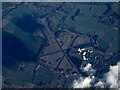
4
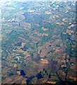
Former RAF Ouston from the air
The airfield is now known as Albemarle Barracks and is home to the 39th Regiment Royal Artillery. Newcastle Airport can be seen to the top right.
Here is a http://en.wikipedia.org/wiki/RAF_Ouston to the wikipedia article about RAF Ouston.
Image: © Thomas Nugent
Taken: 8 Oct 2012
0.02 miles
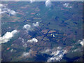
5
Former RAF Ouston from the air
The airfield is now known as Albemarle Barracks and is home to the 39th Regiment Royal Artillery. Here is a http://en.wikipedia.org/wiki/RAF_Ouston to the wikipedia article about RAF Ouston. Viewed from 36,000 feet.
Image: © Thomas Nugent
Taken: 28 Jan 2019
0.02 miles
6
Former RAF Ouston from the air
The disused airfield near Heddon on the Wall is still in military use https://forgottenairfields.com/airfield-ouston-957.html . Viewed from a Prague bound flight from Glasgow.
Image: © Thomas Nugent
Taken: 10 Feb 2020
0.02 miles
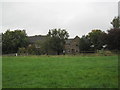
7
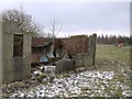
Ruined military building near Nesbitt Hill Head
Image: © Andrew Curtis
Taken: 10 Feb 2012
0.03 miles
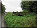
8
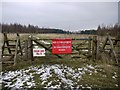
Entrance to RAF Ouston near Nesbitt Hill Head
Stiles provided but entry not encouraged.
Somewhere within the restricted zone of the disused airfield is site of the deserted medieval village of Nesbitt. The village existed in the C12th, when it was the property of Hexham Priory.
Image: © Andrew Curtis
Taken: 10 Feb 2012
0.04 miles
10
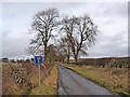
The road to Nesbitt Hill Head
Off the B6309.
Image: © Oliver Dixon
Taken: 13 Jan 2011
0.23 miles