IMAGES TAKEN NEAR TO
Stamfordham, NEWCASTLE UPON TYNE, NE18 0LD
Introduction
This page details the photographs taken nearby to NE18 0LD by members of the Geograph project.
The Geograph project started in 2005 with the aim of publishing, organising and preserving representative images for every square kilometre of Great Britain, Ireland and the Isle of Man.

There are currently over 7.5m images from over14,400 individuals and you can help contribute to the project by visiting https://www.geograph.org.uk
Image Map
Images are licensed for reuse under creativecommons.org/licenses/by-sa/2.0
Notes
- Clicking on the map will re-center to the selected point.
- The higher the marker number, the further away the image location is from the centre of the postcode.
Image Listing (4 Images Found)
Images are licensed for reuse under creativecommons.org/licenses/by-sa/2.0
Image
Details
Distance
1
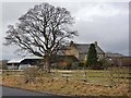
Ouston Farm
By a double bend on the B6309.
Image: © Oliver Dixon
Taken: 13 Jan 2011
0.02 miles
2
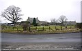
Ouston Farm
One of the outbuildings of the farm was fortified and used as a pillbox during World War II for the defence of RAF Ouston.
Image: © Andrew Curtis
Taken: 10 Feb 2012
0.04 miles
4
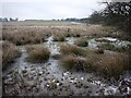
Field pond, Ouston
Pike Hill, behind, was the site of a Bronze Age tumulus. Excavation of the mound in 1926 revealed two burial cists containing human bones and also an urn, which is now lost. Some of the stone slabs, which formed the cists, were carved with cup and ring patterns. One incised slab was presented to the Museum of Antiquities in Newcastle and is recorded here http://archaeologydataservice.ac.uk/era/section/panel/overview.jsf?eraId=1897 and as a 3D model here http://archaeologydataservice.ac.uk/era/section/experience/exp_photogram.jsf
Image: © Andrew Curtis
Taken: 10 Feb 2012
0.08 miles