IMAGES TAKEN NEAR TO
Pear Tree Terrace, NEWCASTLE UPON TYNE, NE17 7ES
Introduction
This page details the photographs taken nearby to Pear Tree Terrace, NE17 7ES by members of the Geograph project.
The Geograph project started in 2005 with the aim of publishing, organising and preserving representative images for every square kilometre of Great Britain, Ireland and the Isle of Man.

There are currently over 7.5m images from over14,400 individuals and you can help contribute to the project by visiting https://www.geograph.org.uk
Image Map
Images are licensed for reuse under creativecommons.org/licenses/by-sa/2.0
Notes
- Clicking on the map will re-center to the selected point.
- The higher the marker number, the further away the image location is from the centre of the postcode.
Image Listing (10 Images Found)
Images are licensed for reuse under creativecommons.org/licenses/by-sa/2.0
Image
Details
Distance
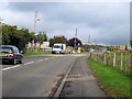
2

View down Mill Road, Chopwell
Chopwell is built on the steep slopes on the northern side of the Derwent Valley, giving extensive views over the southern slopes, as shown here.
Image: © Robert Graham
Taken: 25 Jun 2014
0.09 miles
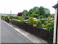
7
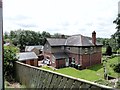
Peartree farm, Chopwell
One of the farms which predate the present village of Chopwell. Until the end of the C19, Chopwell was a purely rural agricultural settlement. After this time, the colliery was sunk and housing started to be built for the mine workers. This farm was already present on the 1862 First Series Ordnance Survey map. The farmhouse shown here is obviously not from that time, but a C20 rebuild.
Image: © Robert Graham
Taken: 25 Jun 2014
0.22 miles
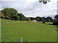
8
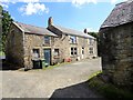
Farmhouse at Tongue Burns, Blackhall Mill
Old farm on the east side of the village. This is a wonderful example of a linear type farmhouse, and in a fairly unaltered condition. The left hand part of the building would have originally been a byer for cattle with a hayloft over. This was a very common type of farmstead in the C18 and early C19 in this area.
Image: © Robert Graham
Taken: 9 Jul 2014
0.22 miles
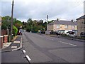
10
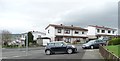
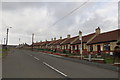
Moorland View and Mill Road, Chopwell
Semis are untypical in Chopwell. Chopwell was categorised as a "category D village" by Durham County Council. With the decline of coal-mining locally, 114 villages were classified in this way in 1951, and another seven in 1964, including Chopwell. They were left to wither and die, without economic assistance or development. The policy ended in 1977, but many still have an old fashioned air, contrasting with newer areas of commuter housing.
Image: © Christine Johnstone
Taken: 12 Apr 2012
0.25 miles