IMAGES TAKEN NEAR TO
Moraine Crescent, NEWCASTLE UPON TYNE, NE17 7DX
Introduction
This page details the photographs taken nearby to Moraine Crescent, NE17 7DX by members of the Geograph project.
The Geograph project started in 2005 with the aim of publishing, organising and preserving representative images for every square kilometre of Great Britain, Ireland and the Isle of Man.

There are currently over 7.5m images from over14,400 individuals and you can help contribute to the project by visiting https://www.geograph.org.uk
Image Map (Loading...)


Getting Data...Please wait
Leaflet Map data © OpenStreetMap
Images are licensed for reuse under creativecommons.org/licenses/by-sa/2.0
Notes
- Clicking on the map will re-center to the selected point.
- The higher the marker number, the further away the image location is from the centre of the postcode.
Image Listing (28 Images Found)
Images are licensed for reuse under creativecommons.org/licenses/by-sa/2.0
Image
Details
Distance
1
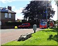
Bus stop on River View
This is at the west edge of Blackhall Mill village. The bus turns here and goes back along the road to the main street. This service, the No 47, connects the village to Newcastle.
Image: © Robert Graham
Taken: 21 Jun 2019
0.05 miles
2
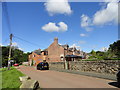
Beech Grove at Blackhall Mill
Blackhall Mill is a C19 mining village, with the pits long gone of course. This C19 street, and its neighbour, Fife Terrace, were miners houses originally. The colliery was a short distance to the west. They now form the western edge of the village.
Image: © Robert Graham
Taken: 21 Jun 2019
0.06 miles
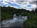
3
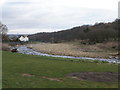
River Derwent at Blackhall Mill, after a flood
The River Derwent at Blackhall Mill, after a major flood has stripped the soil and vegetation from the far bank.
Image: © john durkin
Taken: 26 Feb 2009
0.06 miles
4
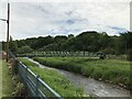
Blackhall Mill Footbridge
This bridge built around 2001 is the latest to link the villages of Blackhall Mill and Hamsterley. More information on this and earlier crossings at The Bridges on the Tyne website https://www.bridgesonthetyne.co.uk/blackfb.html
Image: © Anthony Foster
Taken: 20 Jun 2021
0.07 miles
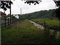
6
Footbridge at Blackhall Mill
This steel girder footbridge spans the River Derwent on the western side of the village. It carries the footpath which leads south to Hamsterley and the main A694 road. Constructed in 2001.
Image: © Robert Graham
Taken: 21 Jun 2019
0.07 miles
7
Footbridge connecting Hamsterley and Blackhall Mill
Image: © Roger Smith
Taken: 30 Sep 2009
0.08 miles
9
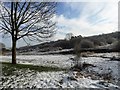
Banks of the Derwent at Blackhall Mill
Winter scene at the west end of the village.
Image: © Robert Graham
Taken: 16 Jan 2013
0.09 miles
10
Footbridge across the Derwent River at Blackhall Mill
Image: © Mick Watson
Taken: 17 Aug 2006
0.10 miles