IMAGES TAKEN NEAR TO
West Meadows, NEWCASTLE UPON TYNE, NE17 7BG
Introduction
This page details the photographs taken nearby to West Meadows, NE17 7BG by members of the Geograph project.
The Geograph project started in 2005 with the aim of publishing, organising and preserving representative images for every square kilometre of Great Britain, Ireland and the Isle of Man.

There are currently over 7.5m images from over14,400 individuals and you can help contribute to the project by visiting https://www.geograph.org.uk
Image Map
Images are licensed for reuse under creativecommons.org/licenses/by-sa/2.0
Notes
- Clicking on the map will re-center to the selected point.
- The higher the marker number, the further away the image location is from the centre of the postcode.
Image Listing (30 Images Found)
Images are licensed for reuse under creativecommons.org/licenses/by-sa/2.0
Image
Details
Distance
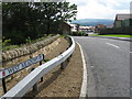
2
Chopwell War Memorial
Stands by the side of the main road through the village,
Image: © Robert Graham
Taken: 23 Feb 2012
0.08 miles
3
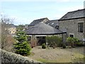
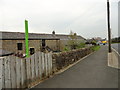
Gin gang at West Farm, Chopwell
Now converted for residential use.
Image: © Oliver Dixon
Taken: 21 Mar 2019
0.08 miles
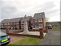
4
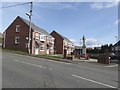
Monument Court, Chopwell
Small development of modern houses centred on the village war memorial.
Image: © Oliver Dixon
Taken: 21 Mar 2019
0.09 miles
5
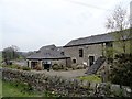
Gin gang at West Farm, Chopwell
This former farm is at the north end of the present village. Prior to the founding of Chopwell colliery in the early C20, this was the centre of the small hamlet called West Chopwell. The rest of the village was built after the pit opened. This picture shows a former gin gang against the barn to the right. All now converted to residential use. A gin gang was a building which contained a horse engine which powered a threshing machine in the adjacent barn. They were common in the early C19, which would date these buildings.
Image: © Robert Graham
Taken: 30 Apr 2014
0.09 miles
6
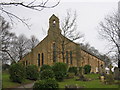
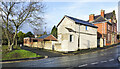
St John the Evangelist Church
View of church on Clayton TCE Road just outside Chopwell.
Image: © Colin Edgar
Taken: 13 Jan 2006
0.09 miles
7
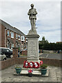
Chopwell War Memorial
Designed by A & F Manuelle of London the memorial was unveiled on 16 June 1923 by Sir Thomas Oliver before a crowd of 7000. It is listed, Grade II.
Links
Historic England Listing https://historicengland.org.uk/listing/the-list/list-entry/1025171
North East War Memorials Project http://www.newmp.org.uk/detail.php?contentId=6872
Image: © Anthony Foster
Taken: 20 Jun 2021
0.09 miles
8
West Farm, Chopwell
This stands at the bottom of Clayton Terrace, beside the junction with Hall Road. This was at the centre of the hamlet of West Chopwell which was all that existed here prior to the building of the colliery village to the south after 1900. These buildings formed the main C19 farm range, with the right hand portion probably being the original farmhouse. All have now been converted to residential use.
Image: © Robert Graham
Taken: 30 Apr 2014
0.09 miles
9
Buildings on Hall Road, Chopwell
Hall Road climbs steeply from Chopwell passing these houses; the nearest one is named 'The Council House'.
Image: © Trevor Littlewood
Taken: 20 Dec 2020
0.10 miles