IMAGES TAKEN NEAR TO
Hexham Road, NEWCASTLE UPON TYNE, NE16 3BN
Introduction
This page details the photographs taken nearby to Hexham Road, NE16 3BN by members of the Geograph project.
The Geograph project started in 2005 with the aim of publishing, organising and preserving representative images for every square kilometre of Great Britain, Ireland and the Isle of Man.

There are currently over 7.5m images from over14,400 individuals and you can help contribute to the project by visiting https://www.geograph.org.uk
Image Map (Loading...)


Getting Data...Please wait
Leaflet Map data © OpenStreetMap
Images are licensed for reuse under creativecommons.org/licenses/by-sa/2.0
Notes
- Clicking on the map will re-center to the selected point.
- The higher the marker number, the further away the image location is from the centre of the postcode.
Image Listing (57 Images Found)
Images are licensed for reuse under creativecommons.org/licenses/by-sa/2.0
Image
Details
Distance
1
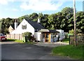
Eighteenth century cottage, Swalwell
Bridge End Cottage, a former toll house beside the Old Derwent Bridge.
Image: © Robert Graham
Taken: 28 Sep 2016
0.02 miles
2

Bridge End Cottage, Swalwell
This is the former toll cottage of 1760 beside the turnpike bridge over the Derwent.
Image: © Robert Graham
Taken: 22 Jun 2016
0.03 miles
3
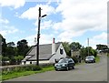
Former toll house, Swalwell
This cottage is beside the River Derwent at Swalwell, beside the old bridge which once carried the Gateshead to Hexham turnpike road over the river. It can be seen on the right. The cottage has a date of 1760 on it. The road is no longer used as there is a new bridge a short distance upstream.
Image: © Robert Graham
Taken: 22 Jun 2016
0.03 miles
4
Path at Derwenthaugh
Entrance from "The Pavilion" to a narrow path for cyclists and walkers which runs along the east bank of the Derwent from Hexham Road down to the Tyne.
Image: © Oliver Dixon
Taken: 1 May 2013
0.04 miles
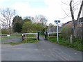
5

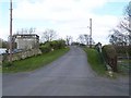
Road leading onto the old bridge at Swalwell
This is the former Gateshead to Hexham Turnpike of the C18. The bridge which can be seen ahead crosses the River Derwent and now is only used as a footbridge.
Image: © Robert Graham
Taken: 28 Sep 2016
0.04 miles
6
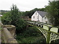
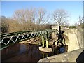
Aqueduct from Old Derwent Bridge
"On the east side [of Old Swalwell Bridge] is an aqueduct in stone and with lattice girders carrying a cast iron/steel water pipe fed from Benwell reservoir carrying water to a pumping station in Gateshead which supplies that town. This somewhat spoils the appearance of the bridge when viewed from upstream to the west but sand blasting and re-painting in 2015 have improved the appearance."
https://www.bridgesonthetyne.co.uk/oldswal.html
The 30" water main of the pipe bridge was laid in 1897 by the Newcastle & Gateshead Water Company.
Image: © Andrew Curtis
Taken: 11 Aug 2019
0.04 miles
7
Old Derwent Bridge at Swalwell
Just downstream from the New Derwent Bridge which now carries Hexham Road, the B6317 Swalwell to Blaydon road.
Image: © Oliver Dixon
Taken: 1 May 2013
0.05 miles
8
Pipe bridge at Swalwell
Over the River Derwent, next to the Old Bridge. It has recently been refurbished, which accounts for the smart paintwork.
Image: © Robert Graham
Taken: 3 Feb 2016
0.06 miles
9
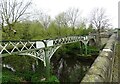
Pipe bridge at Swalwell
Latticed structure carrying a water main over the River Derwent beside Old Swalwell Bridge. It was repaired and repainted in 2015.
Image: © Robert Graham
Taken: 22 Apr 2024
0.07 miles
10
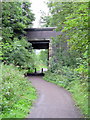
Road bridge over former railway path near Swalwell Bridge
The Swalwell or New Derwent Bridge dates from 1927. It carries the B6317 (Hexham Road) over the River Derwent.
"Underneath the bridge, on the north side, once ran the old 'Main Way', the railway carrying coal and coke to the staiths at Derwenthaugh, and the bridge was built with a sufficient span to accommodate this railway which closed in 1985 and is now a footpath and cycle track."
https://www.bridgesonthetyne.co.uk/swalwell.html
Image: © Andrew Curtis
Taken: 11 Aug 2019
0.07 miles