IMAGES TAKEN NEAR TO
Warkworth Street, NEWCASTLE UPON TYNE, NE15 8DX
Introduction
This page details the photographs taken nearby to Warkworth Street, NE15 8DX by members of the Geograph project.
The Geograph project started in 2005 with the aim of publishing, organising and preserving representative images for every square kilometre of Great Britain, Ireland and the Isle of Man.

There are currently over 7.5m images from over14,400 individuals and you can help contribute to the project by visiting https://www.geograph.org.uk
Image Map (Loading...)


Getting Data...Please wait
Leaflet Map data © OpenStreetMap
Images are licensed for reuse under creativecommons.org/licenses/by-sa/2.0
Notes
- Clicking on the map will re-center to the selected point.
- The higher the marker number, the further away the image location is from the centre of the postcode.
Image Listing (31 Images Found)
Images are licensed for reuse under creativecommons.org/licenses/by-sa/2.0
Image
Details
Distance
1
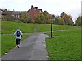
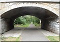
Hadrian's Way, Lemington
Hadrian's Way, a path from Wylam to Newcastle along the north bank of the Tyne, carries both Hadrian's Cycleway
http://www.cycle-routes.org/HADRIANSCYCLEWAY/and Hadrian's Wall National Trail http://www.nationaltrail.co.uk/hadrianswall/.
Image: © Oliver Dixon
Taken: 8 Nov 2008
0.04 miles
3
Lemington
A view of Union Hall Road from Tyne View in Lemington.
Image: © Bobby Clegg
Taken: 21 Jun 2014
0.07 miles
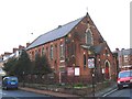
4
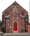
Lemington Methodist Church
There is another photo here Image
The Primitive Methodist Chapel dates from 1891.
Image: © Andrew Curtis
Taken: 28 Jul 2010
0.08 miles
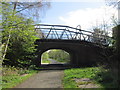
5

Hadrian's Wall Path at Lemington
A view of the flattened arch sandstone and brick lined overbridge that carries Northumberland Road over the ex Scotswood, Newburn & Wylam Railway.
Image: © Bobby Clegg
Taken: 21 Jun 2014
0.11 miles
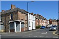
8
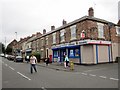
Tyne View, Lemington
Shops at the west end of Lemington's main street viewed towards Lorraine Terrace and Image
Image: © Andrew Curtis
Taken: 28 Jul 2010
0.12 miles
9
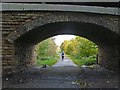
Bridge over Hadrian's Way
This bridge carries Northumberland Road, Lemington over Hadrian's Way, a path from Wylam to Newcastle along the north bank of the Tyne which carries both Hadrian's Cycleway http://www.cycle-routes.org/HADRIANSCYCLEWAY/and Hadrian's Wall National Trail http://www.nationaltrail.co.uk/hadrianswall/.
Image: © Oliver Dixon
Taken: 8 Nov 2008
0.12 miles
10
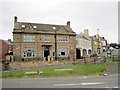
Former Lemington Hotel, Northumberland Road
Housing development on the corner of Northumberland Road where it turns up into Lemington village. The building, now called 'The Hastings' was previously The Lemington Hotel, built in 1897 for the Duke of Northumberland https://web.archive.org/save/http://www.timarchive2.freeuk.com/html/lemington.htm
A photo from 2003 shows the building in a state of dereliction.
Image: © Andrew Curtis
Taken: 28 Jul 2010
0.12 miles