
IMAGES TAKEN NEAR TO
Greenside Crescent, NEWCASTLE UPON TYNE, NE15 7HR
Introduction
This page details the photographs taken nearby to Greenside Crescent, NE15 7HR by members of the Geograph project.
The Geograph project started in 2005 with the aim of publishing, organising and preserving representative images for every square kilometre of Great Britain, Ireland and the Isle of Man.

There are currently over 7.5m images from over14,400 individuals and you can help contribute to the project by visiting https://www.geograph.org.uk
Image Map
Images are licensed for reuse under creativecommons.org/licenses/by-sa/2.0
Notes
- Clicking on the map will re-center to the selected point.
- The higher the marker number, the further away the image location is from the centre of the postcode.
Image Listing (18 Images Found)
Images are licensed for reuse under creativecommons.org/licenses/by-sa/2.0
Image
Details
Distance
1
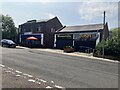
La Famiglia, Mozzarella and The Bindi, Whickham View
Image: © Anthony Foster
Taken: 31 Jul 2024
0.05 miles

5
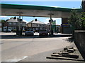
(A very small part of) Hadrian's Wall (2)
This is the first section of Hadrian's Wall to be seen to the west of Newcastle. It lies in the forecourt of a petrol station at the southwest of the roundabout at the junction of West Road and Denton Road.
Image: © Mike Quinn
Taken: 9 Jun 2008
0.20 miles
6
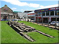
(Part of) Hadrian's Wall (2)
This section is about 25 yards west of Image
Image: © Mike Quinn
Taken: 9 Jun 2008
0.21 miles
7
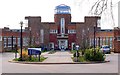
John Marley Centre, Whickham View, Benwell
Formerly, Whickham View Schools, dating from 1936-8, now part of Newcastle's West End College. A Grade II Listed Building https://historicengland.org.uk/listing/the-list/list-entry/1024807
There is another photo and description here Image
There is a statue of Sir John Marley (1590 - 1673) http://www.northumbria.info/Pages/marley.html in the city centre Image
Image: © Andrew Curtis
Taken: 23 Mar 2012
0.22 miles
8
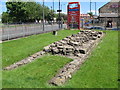
(Part of) Hadrian's Wall
This section is about 25 yards west of Image
Image: © Mike Quinn
Taken: 9 Jun 2008
0.22 miles
9
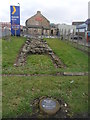
Hadrian's Wall: Denton Burn
The plaque in the foreground states that this section of wall was revealed in 1927.
In the background is Solomons Indian Restaurant: The building used to be the farmhouse of Thorntree Farm
Image: © Anthony Foster
Taken: 1 Mar 2013
0.22 miles
10
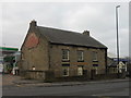
Solomons, Denton Burn
The building used to be the farmhouse of Thorntree Farm.
To the left is a very small section of Hadrian's Wall.
Image: © Anthony Foster
Taken: 1 Mar 2013
0.22 miles