IMAGES TAKEN NEAR TO
Forth Banks, NEWCASTLE UPON TYNE, NE1 3AN
Introduction
This page details the photographs taken nearby to Forth Banks, NE1 3AN by members of the Geograph project.
The Geograph project started in 2005 with the aim of publishing, organising and preserving representative images for every square kilometre of Great Britain, Ireland and the Isle of Man.

There are currently over 7.5m images from over14,400 individuals and you can help contribute to the project by visiting https://www.geograph.org.uk
Image Map
Images are licensed for reuse under creativecommons.org/licenses/by-sa/2.0
Notes
- Clicking on the map will re-center to the selected point.
- The higher the marker number, the further away the image location is from the centre of the postcode.
Image Listing (914 Images Found)
Images are licensed for reuse under creativecommons.org/licenses/by-sa/2.0
Image
Details
Distance
1
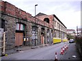
Pottery Lane north-east of the railway bridge
Showing the side and rear of Image
Pottery Lane takes its name from the former Newcastle Pottery which was started in this vicinity around 1800 by Addison and Falconer. It was later operated by Redhead, Wilson, and Co., and then Wallace and Co. http://collections.vam.ac.uk/item/O149393/mug/
Image: © Andrew Curtis
Taken: 28 Nov 2011
0.01 miles
2
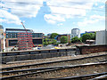
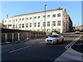
Building site at Forth Banks
Viewed from a departing south bound train from Newcastle Central.
Image: © Thomas Nugent
Taken: 3 Jun 2017
0.02 miles
3
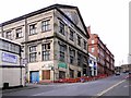
Forth Banks House & Kings House, Forth Banks
See description here Image
Image: © Andrew Curtis
Taken: 28 Nov 2011
0.03 miles
4
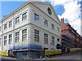
Forth Banks House & Kings House (undergoing renovation)
The old concrete building of the Forth Goods Station is scrubbing up nicely to become part of the new Police Station. A fair bit to be done yet inside.
See previous photo and description here Image
Image: © Andrew Curtis
Taken: 3 Apr 2013
0.03 miles
5
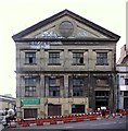
Forth Banks House
The building was built 1905-1906 as a goods warehouse for the Newcastle to Carlisle railway line. At the rear of the building was the huge North Eastern Railway's Forth Banks Goods Station, designed by Thomas Prosser in 1866 http://www.flickr.com/photos/newcastlelibraries/4080142059
This was cut in two by the building of the approach viaduct from Central Station to the King Edward Bridge (1902-1906) leaving only the under-storey of the Goods Station with its arches along Pottery Lane Image The existing building shown here, fronting onto Forth Banks is a ferro-concrete goods shed of three storeys designed by William Bell and built by Mouchel's Hennebique Company. It is a Grade II Listed Building.
http://www.heritagegateway.org.uk/Gateway/Results_Single.aspx?uid=1072614&resourceID=5 http://www.pastscape.org.uk/hob.aspx?hob_id=954973 https://web.archive.org/web/20200625211241/https://www.pastscape.org.uk/hob.aspx?hob_id=954973
Along with the neighbouring Kings House Image, this building is destined to become part of a new £37 million Police Station http://www.journallive.co.uk/north-east-news/todays-news/2011/11/11/work-begins-on-new-police-station-at-forth-banks-newcastle-61634-29757040/ http://www.chroniclelive.co.uk/north-east-news/evening-chronicle-news/2010/10/22/plans-unveiled-for-new-37m-police-station-72703-27525468/ http://www.skyscrapercity.com/showthread.php?t=1345643
Image: © Andrew Curtis
Taken: 28 Nov 2011
0.03 miles
6
Forth Banks
There is a description of the building on the corner of Pottery Lane, now renovated for the new Police Station, here Image
The 1904 Grade II-listed warehouse, one of the UK’s first reinforced concrete structures, is now home to Northumbria Police Station's new custodial suite. It is a 50-cell complex, monitored by CCTV and a modern computer system.
Image: © Andrew Curtis
Taken: 23 Dec 2015
0.03 miles
7
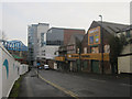
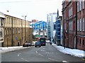
Looking down Forth Banks, Newcastle upon Tyne
Looking down Forth Banks. A modern building at the end of the street contrasts with the dilapidated buildings closer to the camera and the cleared site on the left. Queen Elizabeth II Metro Bridge is visible at the end of the street crossing the River Tyne.
Image: © Graham Robson
Taken: 12 Nov 2012
0.03 miles
8
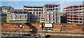
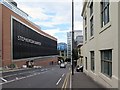
The Forge
Residential development in the 'Stephenson Quarter' in Newcastle upon Tyne.
Image: © Peter McDermott
Taken: 16 May 2018
0.03 miles
9
Forth Banks
Image: © Andrew Curtis
Taken: 13 Aug 2015
0.04 miles
10
Forth Banks
The name 'Forth' is derived from 'Frith', meaning a pasture or shaded place. This refers to an area just outside the Town Walls which was used for recreation in the mid-C16th. It was bounded to the west by the Skinner Burn and was the site of Newcastle's first hospital or Infirmary which opened in 1751 http://research.ncl.ac.uk/nsa/tl1.htm
Although now completely underground, the Skinner Burn is still remembered by Skinnerburn Road which joins the bottom of Forth Banks on the right.
There is an interesting photo on this site from 1978 showing the Metro Bridge being built over Forth Banks Image and a more recent one from further down the hill here Image
There is a c1900 photo of Forth Banks here http://www.flickr.com/photos/newcastlelibraries/4081787082/
Image: © Andrew Curtis
Taken: 30 Nov 2010
0.04 miles